IMAGES TAKEN NEAR TO
Buckmans Road, CRAWLEY, RH11 7DS
Introduction
This page details the photographs taken nearby to Buckmans Road, RH11 7DS by members of the Geograph project.
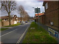
The Geograph project started in 2005 with the aim of publishing, organising and preserving representative images for every square kilometre of Great Britain, Ireland and the Isle of Man.

There are currently over 7.5m images from over14,400 individuals and you can help contribute to the project by visiting https://www.geograph.org.uk
Image Map
Images are licensed for reuse under creativecommons.org/licenses/by-sa/2.0
Notes
- Clicking on the map will re-center to the selected point.
- The higher the marker number, the further away the image location is from the centre of the postcode.
Image Listing (179 Images Found)
Images are licensed for reuse under creativecommons.org/licenses/by-sa/2.0
Image
Details
Distance
1
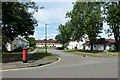
The Link, West Green, Crawley
An example of the planning of the new town in its earlier times. The far green is linked to another stub road off to the right.
Image: © Robin Webster
Taken: 13 Aug 2013
0.04 miles
2
Sunnymead, West Green, Crawley
One of the earlier new town developments.
Image: © Robin Webster
Taken: 12 Aug 2013
0.05 miles
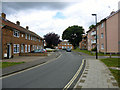
3
Houses on Town Barn Road, West Green, Crawley
Earlier examples of Crawley's expansion as a new town.
Image: © Robin Webster
Taken: 13 Aug 2013
0.07 miles
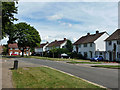
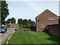
4
Buckman's Road at Kite Close
Early new town planning when space was not at a premium.
Image: © Robin Webster
Taken: 13 Aug 2013
0.08 miles
5
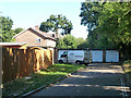
Lock-up garages, Townmead, West Green, Crawley
Accessed from the end of one of the branches of Townmead.
Image: © Robin Webster
Taken: 31 Aug 2013
0.08 miles
6
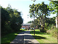
Footpath and cycle track, West Green, Crawley
This runs from London Road to Town Barn Road, and has the appearance of an old way from before the new town was developed.
Image: © Robin Webster
Taken: 31 Aug 2013
0.08 miles
7
Flats, Sunnymead, West Green, Crawley
One of several blocks down this side of the road built on a three-pointed star plan.
Image: © Robin Webster
Taken: 12 Aug 2013
0.09 miles
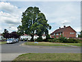
8
Town Barn Road, West Green, Crawley
Named after Town Barn, which stood roughly where the bungalows are in pre-new town days, but seems to have gone without trace.
Image: © Robin Webster
Taken: 1 Sep 2013
0.09 miles
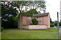
10
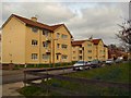
Sunnymead Conservation Area
The Crawley Development Corporation designed Sunnymead Flats in the 1950s. They were originally built for the workers involved in the construction of the New Town. Sunnymead Flats represent an example of early New Town housing and are considered to be of architectural significance. They were designated as a Conservation Area in 1997 http://www.crawley.gov.uk/stellent/idcplg?IdcService=SS_GET_PAGE&ssDocName=INT010073
Image: © Paul Gillett
Taken: 5 Mar 2011
0.10 miles