IMAGES TAKEN NEAR TO
Evans Close, CRAWLEY, RH10 7WN
Introduction
This page details the photographs taken nearby to Evans Close, RH10 7WN by members of the Geograph project.
The Geograph project started in 2005 with the aim of publishing, organising and preserving representative images for every square kilometre of Great Britain, Ireland and the Isle of Man.

There are currently over 7.5m images from over14,400 individuals and you can help contribute to the project by visiting https://www.geograph.org.uk
Image Map
Images are licensed for reuse under creativecommons.org/licenses/by-sa/2.0
Notes
- Clicking on the map will re-center to the selected point.
- The higher the marker number, the further away the image location is from the centre of the postcode.
Image Listing (102 Images Found)
Images are licensed for reuse under creativecommons.org/licenses/by-sa/2.0
Image
Details
Distance
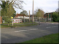
1
Evans Close, Maidenbower, Crawley
Off Maidenbower Drive.
Image: © Robin Webster
Taken: 6 Jul 2021
0.00 miles
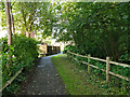
2
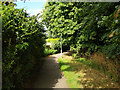
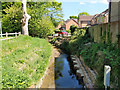
Path along brook, Maidenbower
Towards Balcombe Road, with the brook, which may still be called the Gatwick Stream, down on the right.
Image: © Robin Webster
Taken: 5 Jul 2020
0.02 miles
3
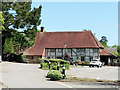
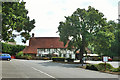
Frogshole Farm public house
Still boarded up from the fire in February (2007) but the enclosing fences now display planning applications (so things are looking up). The pub's name is not a contrivance of Olde Worlde corporate branding as this actually was the farmhouse for Frogshole Farm. The timber-framed building dates from the 16th century with numerous modifications over the centuries (and probably a few fires too!) Most of surrounding development is built on the fields of the old farm so Maidenbower could well have been named Frogshole instead.
Image: © Andy Potter
Taken: 14 Oct 2007
0.03 miles
4
Stream upstream of Maidenbower Drive
One of the streams which feeds into the Gatwick Stream and thence the River Mole. It may even be the Gatwick Stream, as the other major stream is called Stanford Brook.
Image: © Robin Webster
Taken: 26 Apr 2020
0.03 miles
5
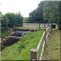
Screen on brook under Maidenbower Drive
There is some sort of monitoring system fitted, but it is not on the list of EA transmitting stations, so what is it for? Detecting screen blockage?
Image: © Robin Webster
Taken: 5 Jul 2020
0.03 miles
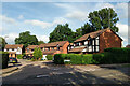
6
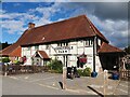
Frogshole Farm
"Free house and dining" according to its sign.
Image: © Robin Webster
Taken: 8 Aug 2013
0.03 miles
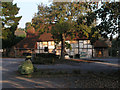
8
Frogshole Farm after a Fire
Originally a farmhouse, latterly a pub, the site is cordoned off after a fire on 8 Feb 2007. Outwardly in good shape, according to the newspaper report about 50% was damaged and the roof of the kitchen collapsed.
Image: © Robin Webster
Taken: 14 Feb 2007
0.04 miles
9
Path by Gatwick Stream, Maidenbower, Crawley
Towards Maidenbower Drive.
Image: © Robin Webster
Taken: 6 Jul 2021
0.04 miles