IMAGES TAKEN NEAR TO
Old Orchards, Church Road, CRAWLEY, RH10 7QA
Introduction
This page details the photographs taken nearby to Old Orchards, Church Road, RH10 7QA by members of the Geograph project.
The Geograph project started in 2005 with the aim of publishing, organising and preserving representative images for every square kilometre of Great Britain, Ireland and the Isle of Man.

There are currently over 7.5m images from over14,400 individuals and you can help contribute to the project by visiting https://www.geograph.org.uk
Image Map (Loading...)


Getting Data...Please wait
Leaflet Map data © OpenStreetMap
Images are licensed for reuse under creativecommons.org/licenses/by-sa/2.0
Notes
- Clicking on the map will re-center to the selected point.
- The higher the marker number, the further away the image location is from the centre of the postcode.
Image Listing (322 Images Found)
Images are licensed for reuse under creativecommons.org/licenses/by-sa/2.0
Image
Details
Distance
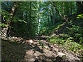
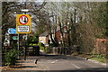
1
Old railway cutting east of Church Road, Worth
The former Three Bridges - East Grinstead line, now with a public footpath along it as far as the next bridge. There is no direct access at Church Road.
Image: © Robin Webster
Taken: 2 Mar 2018
0.05 miles
3
Footpath Seen From Church Road Bridge
Looking towards the east.
Image: © Peter Trimming
Taken: 29 Mar 2019
0.06 miles
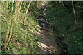
4
Public footpath along old railway, Crawley
Footpath 104bW runs from Balcombe Road to the bridge carrying path 92W, along a cutting of the old Three Bridges - East Grinstead railway. There is no intermediate access, and unfortunately the western part between Church Road (no access) and Balcombe Road is in appalling condition. I chose a very dry time, as I knew it could get wet (it still was locally), but did not expect so many fallen trees at awkward heights. This part east of Church Road is reasonable.
Image: © Robin Webster
Taken: 10 Aug 2022
0.06 miles
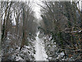
6

Church Road, Worth, after snow
The pavement is on the left, but anything goes today.
Image: © Robin Webster
Taken: 6 Jan 2010
0.07 miles
7
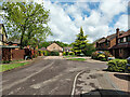
Stepped parapet, Church Road bridge over old railway line
The east parapet. At the near end, about five bricks up, is a cut mark at 100.248 m above sea level Image, so the road surface is gently rising through 100 m here. The steps are of two brick courses.
Image: © Robin Webster
Taken: 16 May 2021
0.07 miles
8
Public footpath 92W, Maidenbower, Crawley
Using here the pavement of part of Saxon Road, crossing the end of Osmund Close and then using its old route towards an end-on junction with path 90W to Turners Hill Road.
Image: © Robin Webster
Taken: 24 May 2021
0.07 miles
9
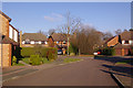
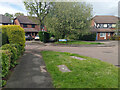
Saxon Road, Worth
All the streets in this estate have names with a Saxon theme, presumably because of the nearby Saxon church of St Nicholas (see Image).
Image: © Ian Capper
Taken: 27 Dec 2008
0.07 miles
10
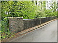
Church Road Bridge
The road passes over a former railway cutting, with the Worth Way cycle track/footpath turning left at this point and dropping down into the cutting.
Image: © Peter Trimming
Taken: 29 Mar 2019
0.07 miles