IMAGES TAKEN NEAR TO
Beckford Way, CRAWLEY, RH10 7LT
Introduction
This page details the photographs taken nearby to Beckford Way, RH10 7LT by members of the Geograph project.
The Geograph project started in 2005 with the aim of publishing, organising and preserving representative images for every square kilometre of Great Britain, Ireland and the Isle of Man.

There are currently over 7.5m images from over14,400 individuals and you can help contribute to the project by visiting https://www.geograph.org.uk
Image Map (Loading...)


Getting Data...Please wait
Leaflet Map data © OpenStreetMap
Images are licensed for reuse under creativecommons.org/licenses/by-sa/2.0
Notes
- Clicking on the map will re-center to the selected point.
- The higher the marker number, the further away the image location is from the centre of the postcode.
Image Listing (57 Images Found)
Images are licensed for reuse under creativecommons.org/licenses/by-sa/2.0
Image
Details
Distance
1
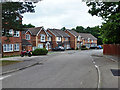
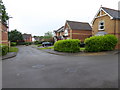
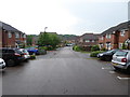
Houses on Beckford Way, Maidenbower, Crawley
Nearly the most southerly point in Maidenbower, confined between the railway and the M23.
Image: © Robin Webster
Taken: 17 Aug 2013
0.04 miles
3
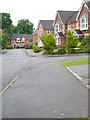
Houses on Beckford Way, Maidenbower, Crawley
Nearly the most southerly point in Maidenbower, confined between the railway and the M23.
Image: © Robin Webster
Taken: 17 Aug 2013
0.04 miles
4
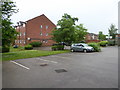
Looking across parking area at east end of Bolton Road
Image: © Shazz
Taken: 7 Jun 2016
0.06 miles
6
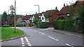
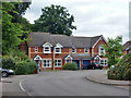
1990/2000s Housing. Another view of Chapman Road, Crawley, West Sussex
This short road (150m long) has a variety of housing - all helping to make the high packing density feel less oppressive. These houses are in the middle section of the road and are generally bigger than those shown near the street name sign. The origins of the area being a forest are evident in this view, with a couple of very large and mature trees left in situ to add interest to the area.
Image: © Pete Chapman
Taken: 15 Sep 2005
0.06 miles
7
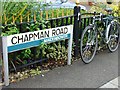
Chapman Road, Maidenbower - general pattern of street name signs in Crawley.
Sign for Chapman Road, next to Chapman's bike!
The "neighbourhood" identity of the various parts of Crawley is emphasised by all of the street name signs having the name of the neighbourhood included on the bottom right corner of the sign (as shown in the picture). Additionally, each neighbourhood has its own colour for the band across the centre of the sign, Maidenbower uses a blue colour. Other area colours include: Northgate (green); Manor Royal Industrial Estate (Black - "Industrial").
Image: © Pete Chapman
Taken: 15 Sep 2005
0.06 miles
8
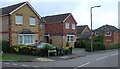
1990/2000s Housing Estate - Chapman Road, Maidenbower Neighbourhood of Crawley, West Sussex
The newest of Crawleys "Neighbourhood" areas. This part of Maidenbower was built on the site of Worth Forest and spreads into the NW corner of this grid square. As was the fashion at the time, the houses on this housing estate are built to appear slightly different from their immediate neighbours. Amazing how many detached/semi-detached houses can fit in such a small area! The photo shows the street name sign in front of the car. All the street name signs in Crawley are of this general pattern (see supplemental photo for details).
Image: © Pete Chapman
Taken: 15 Sep 2005
0.06 miles
10
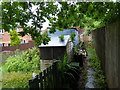
Back garden access for Bolton Road
Oops, I thought this was a connecting twitten, not private access!
Image: © Shazz
Taken: 7 Jun 2016
0.07 miles