IMAGES TAKEN NEAR TO
St. Andrews Close, READING, RG7 6BL
Introduction
This page details the photographs taken nearby to St. Andrews Close, RG7 6BL by members of the Geograph project.
The Geograph project started in 2005 with the aim of publishing, organising and preserving representative images for every square kilometre of Great Britain, Ireland and the Isle of Man.

There are currently over 7.5m images from over14,400 individuals and you can help contribute to the project by visiting https://www.geograph.org.uk
Image Map
Images are licensed for reuse under creativecommons.org/licenses/by-sa/2.0
Notes
- Clicking on the map will re-center to the selected point.
- The higher the marker number, the further away the image location is from the centre of the postcode.
Image Listing (58 Images Found)
Images are licensed for reuse under creativecommons.org/licenses/by-sa/2.0
Image
Details
Distance
1
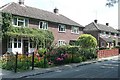
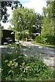
St. Andrew's Terrace, Bradfield
A modest row of former council houses in Bradfield, enlivened by the pride that the residents take in their gardens.
Image: © Graham Horn
Taken: 27 Jul 2008
0.02 miles
2
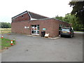
Bradfield Telephone Exchange, West Berkshire
Situated North of the village, this TE is of a standard design dating from the early 1970s and common throughout the United Kingdom. It has the code THBFD, and provides telephone and broadband services to 696 residential and 60 non-residential premises in Bradfield plus Southend and Stanford Dingley nearby. A black refuse bin and a yellow grit salt bin can be seen in front of this TE. This TE has the numbering ranges (01189) 744xxx, 745xxx, the (01189) referring to the Reading group of twenty two TEs, and its postcode is RG7 6BL.
Image: © David Hillas
Taken: 18 Aug 2018
0.03 miles
3
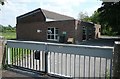
Bradfield telephone exchange
One of life's unexciting but essential buildings.
Image: © Graham Horn
Taken: 27 Jul 2008
0.03 miles
4
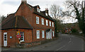
Bridge House, Ashampstead Road, Bradfield (Berks)
A mid-C18 house now the Bradfield College Medical Centre.
Image: © David Kemp
Taken: 14 Apr 2021
0.05 miles
5
Back of Bradfield
On the footpath out of Bradfield to the west, access drives to some private houses behind Home Farm.
Image: © Graham Horn
Taken: 27 Jul 2008
0.05 miles
6
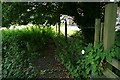
Corner by the telephone exchange
One of lifes unobtrusive, not particularly interesting, but occurs everywhere corners, by a stile at the back of the telephone exchange, where the hedge bindweed and the nettles can grow in peace and lots of little insects and small mammals go about their undisturbed lives.
Image: © Graham Horn
Taken: 27 Jul 2008
0.05 miles
7
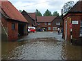
Flooding in Bradfield
Following the earlier deluge, the River Pang flows into this courtyard beside Bridge House.
Image: © Andrew Smith
Taken: 20 Jul 2007
0.06 miles
8
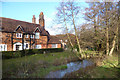
River Pang in Bradfield
The Pang is in two channels through the village, with the main flow passing through an old mill.
This is the non-millstream branch flowing past a house which is now a medical centre for Bradfield College.
Image: © Des Blenkinsopp
Taken: 2 Jan 2014
0.07 miles
9
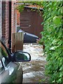
Side passage, Bradfield
Acting as a channel of the River Pang following a deluge earlier in the day. The tidemark on the gate shows the height that the water had reached during the flash flooding that followed the downpour (which had ceased about six hours earlier).
Image: © Andrew Smith
Taken: 20 Jul 2007
0.10 miles
10
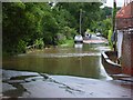
Ashampstead Road, Bradfield
Taken on a day when a deluge of rain had caused very widespread flash flooding and longer lasting flooding of rivers. This is taken where the road crosses the River Pang which was flooding several cottages in the village.
Image: © Andrew Smith
Taken: 20 Jul 2007
0.10 miles