IMAGES TAKEN NEAR TO
Victor Place, READING, RG7 5HU
Introduction
This page details the photographs taken nearby to Victor Place, RG7 5HU by members of the Geograph project.
The Geograph project started in 2005 with the aim of publishing, organising and preserving representative images for every square kilometre of Great Britain, Ireland and the Isle of Man.

There are currently over 7.5m images from over14,400 individuals and you can help contribute to the project by visiting https://www.geograph.org.uk
Image Map
Images are licensed for reuse under creativecommons.org/licenses/by-sa/2.0
Notes
- Clicking on the map will re-center to the selected point.
- The higher the marker number, the further away the image location is from the centre of the postcode.
Image Listing (184 Images Found)
Images are licensed for reuse under creativecommons.org/licenses/by-sa/2.0
Image
Details
Distance
1
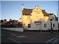
Old people's bungalows, Victor Place, Woolhampton
Image: © Robin Stott
Taken: 7 Mar 2015
0.00 miles
2
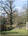
Gate into backland off Victor Place, Woolhampton
A finger of countryside or farmland comes in from the north. The oak tree may once have been part of a field boundary.
Image: © Robin Stott
Taken: 7 Mar 2015
0.01 miles
3
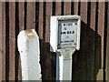
GPSS pipeline markers
The Government Pipeline and Storage System has a route running closely parallel to the A4 for some distance. At settlements it usually deviates, to loop around the housing along the road as it was when installed in the 1940s. Here it appears to have done that, but more recent development has encroached on the route. The left hand post looks like an upright of the original marker which resembled a stile, usually in a hedge. The road boundary is now a garden fence. On the right a more recent marker carries the information plate of Serco Gulf Engineering who operate the pipeline on behalf of the government. The pipeline carries mainly oil products for civil use these days. The GPSS plate is applied beneath.
Image: © Robin Webster
Taken: 7 Mar 2015
0.03 miles
4
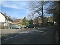
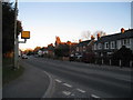
Junction of Victor Place and Woolhampton Hill
The houses up the hill are in the style of local authority houses, doubtless all now in private hands.
Image: © Robin Stott
Taken: 7 Mar 2015
0.03 miles
5
GPSS pipeline crossing point, Woolhampton Hill
The two markers on the left and the white post on the right mark the crossing for the light oil products line. The Government Pipeline and Storage System has a route running closely parallel to the A4 for some distance. At settlements it usually deviates, to loop around the housing along the road as it was when installed around WWII. Here it appears to have done that, but more recent development has meant it runs under the back gardens of houses on Orchard Close to the right. On the left it must be quite a tight squeeze between the housing.
Image: © Robin Webster
Taken: 7 Mar 2015
0.04 miles
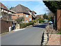
6
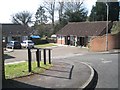
North and upslope on Woolhampton Hill
One house is sold and another is for sale. The turning on the right is Orchard Close, an evocative name: does it record a lost feature? The tree on the left is a young Monkey Puzzle or Chile Pine, Araucaria araucana.
Image: © Robin Stott
Taken: 7 Mar 2015
0.04 miles
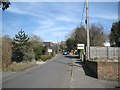
7
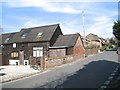
The Old Barn and neighbours, Woolhampton Hill
The Old Barn, left, has timber doors, is timber clad, and is roofed with a corrugated material. The house appearing behind it is being reroofed.
Image: © Robin Stott
Taken: 7 Mar 2015
0.04 miles
8
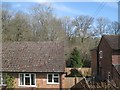
The view northeast from Rowlands Copse, New Road Hill, Woolhampton
At the back of the houses is the southeast tail of woodland named Bushy Pightle in Image
Image: © Robin Stott
Taken: 7 Mar 2015
0.06 miles