IMAGES TAKEN NEAR TO
Goring Lane, READING, RG7 3AY
Introduction
This page details the photographs taken nearby to Goring Lane, RG7 3AY by members of the Geograph project.
The Geograph project started in 2005 with the aim of publishing, organising and preserving representative images for every square kilometre of Great Britain, Ireland and the Isle of Man.

There are currently over 7.5m images from over14,400 individuals and you can help contribute to the project by visiting https://www.geograph.org.uk
Image Map
Images are licensed for reuse under creativecommons.org/licenses/by-sa/2.0
Notes
- Clicking on the map will re-center to the selected point.
- The higher the marker number, the further away the image location is from the centre of the postcode.
Image Listing (31 Images Found)
Images are licensed for reuse under creativecommons.org/licenses/by-sa/2.0
Image
Details
Distance
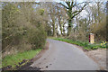
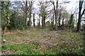
1
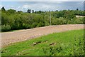
Burghfield Slade
Farmland leading down to Burghfield Slade, a shallow river valley to the east of the village. There is a small reservoir in there somewhere.
Image: © Graham Horn
Taken: 19 May 2009
0.04 miles
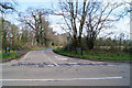
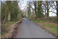
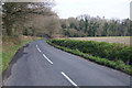
3
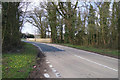
Goring Lane, Wokefield
Goring Lane is the main road through Wokefield. It runs from Burghfield Common to Grazeley Green Road.
Image: © Oscar Taylor
Taken: 23 Apr 2023
0.08 miles
9
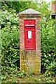
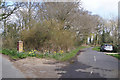
Victorian postbox at Goddard's Green
Still doing stirling service, although it looks as though it has probably been reset in a newer brick pillar.
Image: © Graham Horn
Taken: 13 Jun 2009
0.16 miles