IMAGES TAKEN NEAR TO
Tylorstown, READING, RG4 7XW
Introduction
This page details the photographs taken nearby to Tylorstown, RG4 7XW by members of the Geograph project.
The Geograph project started in 2005 with the aim of publishing, organising and preserving representative images for every square kilometre of Great Britain, Ireland and the Isle of Man.

There are currently over 7.5m images from over14,400 individuals and you can help contribute to the project by visiting https://www.geograph.org.uk
Image Map
Images are licensed for reuse under creativecommons.org/licenses/by-sa/2.0
Notes
- Clicking on the map will re-center to the selected point.
- The higher the marker number, the further away the image location is from the centre of the postcode.
Image Listing (17 Images Found)
Images are licensed for reuse under creativecommons.org/licenses/by-sa/2.0
Image
Details
Distance
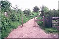
1
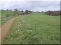
Hemdean Bottom, Caversham, Reading
Popularly known as Bugs' Bottom, a swathe of countryside spared the residential development that affected hillsides to the east and west.
Image: © Andrew Smith
Taken: 25 Jun 2021
0.08 miles
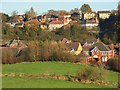
2
Bugs Bottom
The finger of green that was saved from development and is still a popular green space (despite the fact that no people appear in this photo!) Bugs Bottom is the local name, officially sanctioned, although it appears as Hemdean Bottom on most maps.
Image: © Graham Horn
Taken: 24 Feb 2007
0.09 miles
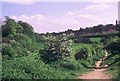
3
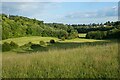
Bugs Bottom
Looking from the rising land to the north, the green finger of parkland can be seen. With development resisted, this remains a well-used area of open land between the residential areas of Emmer Green (left) and Caversham heights (right). Shown on most maps as Hemdean Bottom, the local name (officially used as well) is Bugs Bottom.
Image: © Graham Horn
Taken: 24 Feb 2007
0.11 miles
4
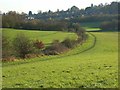
Bugs' Bottom, Caversham
More properly Hemdean Bottom, a tract of green between the houses on the flanks of the valley on either side. It was saved from developers several years ago.
Image: © Andrew Smith
Taken: 16 Nov 2007
0.11 miles
5

Bugs' Bottom, Caversham
The houses of the Caversham encroach on this dry valley which was saved from being developed. A little frost lasted all day in the shade of the trees.
Image: © Andrew Smith
Taken: 16 Nov 2007
0.11 miles
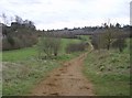
6
a.k.a. Bugs Bottom
The local name is so much more fun...
Image: © Rosalind Mitchell
Taken: 2 May 2005
0.11 miles
7
Hemdean Bottom
Right on the urban/rural fringe to the north of Caversham. A dry valley (marked as Hemdean Bottom on the map but known locally as Bug's Bottom) pushes a rural finger southwards into the town.
Image: © Rosalind Mitchell
Taken: 2 May 2005
0.11 miles
8
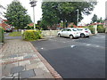
Kidmore Road, from the front car park of the Grosvenor
The Grosvenor pub had a varied menu, but didn't seem to serve Grosvenor pie.
(In early 2017 the Grosvenor was revamped and renamed as the 'Caversham Rose' https://www.thecavershamrosereading.co.uk/ .) A large amount of custom is expected at some times, because it has large car parks front and back, almost squeezing out the rear garden. N.B. We're still in Berkshire here.
Image: © HelenK
Taken: 25 Jun 2016
0.13 miles
9
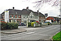
The Grosvenor, Kidmore Road
A large pub/restaurant in Caversham Heights, currently operated by Ember Inns.
Looking at old maps http://www.old-maps.co.uk/maps.html?txtXCoord=470540&txtYCoord=176180 it appears to have been built between the world wars, it was then called Grosvenor House.
Image: © Rose and Trev Clough
Taken: 4 Apr 2014
0.15 miles
10
Bugs' Bottom, Caversham
A small development of houses in the foot of the valley beside green space that was saved from developers. The more distant houses are out of the grid-square and on the fringe of Emmer Green.
Image: © Andrew Smith
Taken: 16 Nov 2007
0.16 miles