IMAGES TAKEN NEAR TO
RG3 5WE
Introduction
This page details the photographs taken nearby to RG3 5WE by members of the Geograph project.
The Geograph project started in 2005 with the aim of publishing, organising and preserving representative images for every square kilometre of Great Britain, Ireland and the Isle of Man.

There are currently over 7.5m images from over14,400 individuals and you can help contribute to the project by visiting https://www.geograph.org.uk
Image Map
Images are licensed for reuse under creativecommons.org/licenses/by-sa/2.0
Notes
- Clicking on the map will re-center to the selected point.
- The higher the marker number, the further away the image location is from the centre of the postcode.
Image Listing (24 Images Found)
Images are licensed for reuse under creativecommons.org/licenses/by-sa/2.0
Image
Details
Distance
1
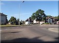
Overdown Road at the junction of Lower Elmstone Drive
Image: © David Howard
Taken: 7 Aug 2016
0.03 miles
2
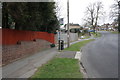
Spot the boundary
The boundary of West Berkshire District and Reading Borough crosses the road here. Lower Elmstone Drive and Overdown Road are the two main distributor roads through the area, with the houses in a maze of cul-de-sacs behind.
Image: © Graham Horn
Taken: 30 Mar 2008
0.05 miles
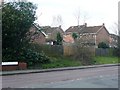
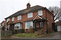
3
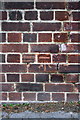
#345 Overdown Road
The house is semi-detached with #343 and has an OS benchmark Image to the right of the wheelie bins.
Image: © Roger Templeman
Taken: 28 Feb 2012
0.06 miles
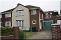
4
Benchmark on front of #345 Overdown Road
Ordnance Survey cut mark benchmark described on the Bench Mark Database at http://www.bench-marks.org.uk/bm40690
Image: © Roger Templeman
Taken: 28 Feb 2012
0.06 miles
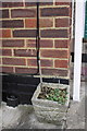
5
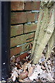
Benchmark on Pierce's Hill wall
Ordnance Survey cut mark benchmark described on the Bench Mark Database at http://www.bench-marks.org.uk/bm41024
Image: © Roger Templeman
Taken: 28 Feb 2012
0.06 miles
6
Pierce's Hill
There is an OS benchmark Image on the wall at the left side of the photo
Image: © Roger Templeman
Taken: 28 Feb 2012
0.06 miles
7
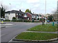
Overdown Road/Dark Lane
Overdown Road climbs gradually from Oxford Road to reach this roundabout. Here two bus services split, one continuing along Westwood Glen where I am standing, the other going off to the left up Dark Lane into the next square. Deepest 1970s and 1980s suburbia.
Image: © Graham Horn
Taken: 30 Mar 2008
0.07 miles
8
Benchmark on #1 Maybough Cottages
Ordnance Survey cut mark benchmark described on the Bench Mark Database at http://www.bench-marks.org.uk/bm41626
Image: © Roger Templeman
Taken: 28 Feb 2012
0.08 miles
9
Maybough Cottages
There is an OS benchmark Image on the side of the right hand house just right of the black downpipe
Image: © Roger Templeman
Taken: 28 Feb 2012
0.08 miles
10
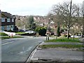
Pierce's Hill
In the middle of suburban Tilehurst, a confusing muddle of roads shared between Reading Borough (closer to the camera) and West Berkshire District (beyond the trees). Some West Berkshire roads are only accessible by going through Reading Borough. It is a hilly landscape and Pierce's Hill has seen its share of vehicles sliding down in the ice and snow.
Image: © Graham Horn
Taken: 30 Mar 2008
0.09 miles