IMAGES TAKEN NEAR TO
Bath Road, READING, RG1 6HR
Introduction
This page details the photographs taken nearby to Bath Road, RG1 6HR by members of the Geograph project.
The Geograph project started in 2005 with the aim of publishing, organising and preserving representative images for every square kilometre of Great Britain, Ireland and the Isle of Man.

There are currently over 7.5m images from over14,400 individuals and you can help contribute to the project by visiting https://www.geograph.org.uk
Image Map
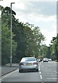
Images are licensed for reuse under creativecommons.org/licenses/by-sa/2.0
Notes
- Clicking on the map will re-center to the selected point.
- The higher the marker number, the further away the image location is from the centre of the postcode.
Image Listing (207 Images Found)
Images are licensed for reuse under creativecommons.org/licenses/by-sa/2.0
Image
Details
Distance
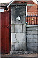
2
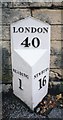
Old Milepost by the A4155, Bath Road, Reading
Cast iron post by the A4155, in parish of Reading (Reading District), Bath Road; Water Pumping Station, West of Brunswick Street, in pavement, against wall of pumping station, 23 yds east of entrance to Water Works, on North side of road. Perry gabled iron casting, erected by the Twyford & Theale turnpike trust in the 19th century.
Inscription reads:-
: READING / 1 : : LONDON / 40 : : NEWBURY / 16 :
Maker:-
: T & J PERRY / READING :
Grade II listed.
List Entry Number: 1366003 https://historicengland.org.uk/listing/the-list/list-entry/1366003
Milestone Society National ID: BE_LB40
Image: © A Rosevear
Taken: 19 Jul 2001
0.06 miles
3
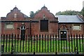
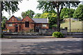
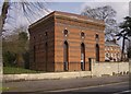
Bath Road reservoir site
This is one of the buildings associated with the reservoir. They are no longer used, and there are plans for houses on the site, creating much controversy as there is a little nature colony grown up in there.
Update 8th October 2009. Reading Borough Council's planning committee has rejected plans for 100 houses to be built on the site, after a big local campaign.
Image: © Graham Horn
Taken: 30 Sep 2008
0.07 miles
4
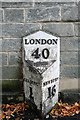
London 40
A mile out of Reading to the west, and 16 east of Newbury, on Bath Road, now the A4, the coaching road from London to Bath.
Image: © Graham Horn
Taken: 30 Sep 2008
0.07 miles
5
Thames Water Bath Road Reading Reservoir & Pumping Station
Image: © Roger Templeman
Taken: 24 Apr 2011
0.07 miles
6
Benchmark on gatepost of #48 Bath Road
Ordnance Survey cut mark benchmark described on the Bench Mark Database at http://www.bench-marks.org.uk/bm37706
Image: © Roger Templeman
Taken: 24 Apr 2011
0.07 miles
7
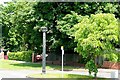
Berkeley Avenue
There is a turning point at the top end of Berkeley Avenue, which was originally a bus terminus. The grey tower with a grill on the top is a sewer vent, intended to prevent the build of gases in the sewers (thanks to Chris Wood for this information).
Image: © Graham Horn
Taken: 29 May 2009
0.07 miles
8
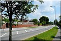
Berkeley Avenue
Very light traffic during the day, but come here at 8 in the morning or 6 in the evening and this road is chocker.
Image: © Graham Horn
Taken: 29 May 2009
0.07 miles
9
Bath Road reservoir site
This is the pumping house for the reservoir, the embankments of which are behind the tree. They are no longer used, and there are plans for houses on the site, creating much controversy as there is a little nature colony grown up in there.
Image: © Graham Horn
Taken: 25 Mar 2007
0.07 miles
10
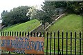
Bath Road reservoir site
This is the embankment of one of the underground reservoirs. They are no longer used, and there are plans for houses on the site, creating much controversy as there is a little nature colony grown up in there. The campaign to save the site is here http://www.savethebathroadreservoir.co.uk/index.html
Image: © Graham Horn
Taken: 30 Sep 2008
0.07 miles