1
Benchmark on the Western Road face of #70 Brunswick Street
Ordnance Survey cut mark benchmark described on the Bench Mark Database at http://www.bench-marks.org.uk/bm37707
Image: © Roger Templeman
Taken: 24 Apr 2011
0.05 miles
2
Brunswick Street, Reading
The mock-tudor building half way along this terrace is a pub, the Forester's Arms. The gable end beyond that is that of a former 17th century silk mill built by Huguenot refugees from the German city of Brunswick (Braunschweig), hence the street's name. The building has since served as pub (the Brunswick Arms) and has now been converted into houses.
Image: © Andrew Smith
Taken: 2 Nov 2007
0.05 miles
3
Brunswick Street
A view north from the car park at 80 Brunswick Street, over the garden of 78 Brunswick Street over to 72 Brunswick Street, a large block of flats. There is terraced housing on the right hand side.
Image: © Oscar Taylor
Taken: 3 Mar 2023
0.05 miles
4
Reading : Haden Square
Looking along Haden Square off Bath Road.
Image: © Lewis Clarke
Taken: 18 Jul 2019
0.06 miles
5
The Foresters Arms
On Brunswick Street, a thriving local.
Image: © Graham Horn
Taken: 30 Sep 2008
0.06 miles
6
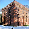
Bath Road reservoir site
This is the attractive Victorian operating building at the Bath Road reservoir site, on the day after snow had fallen over much of south-east England. A combination of Victorian architecture and Reading's history of patterned brickwork has led to a particularly attractive design for such a functional building. This site has been the location of a controversial planning application for housing, including conversion of the buildings. However, there is a small nature reserve here, and the second planning application has recently been rejected (October 2009).
Image: © Graham Horn
Taken: 19 Dec 2009
0.06 miles
7
The Foresters Arms, Brunswick Street
Image: © Stuart Logan
Taken: 24 Feb 2012
0.06 miles
8
Bath Road reservoir site
This is the pumping house for the reservoir, the embankments of which are behind the tree. They are no longer used, and there are plans for houses on the site, creating much controversy as there is a little nature colony grown up in there.
Image: © Graham Horn
Taken: 25 Mar 2007
0.06 miles
9
Bath Road reservoir site
This is the embankment of one of the underground reservoirs. They are no longer used, and there are plans for houses on the site, creating much controversy as there is a little nature colony grown up in there. The campaign to save the site is here http://www.savethebathroadreservoir.co.uk/index.html
Image: © Graham Horn
Taken: 30 Sep 2008
0.06 miles
10
Bath Road reservoir site
One of the buildings on the edge of an area of wildlife that is under threat from a planning application. See also http://www.geograph.org.uk/photo/996973
Image: © don cload
Taken: 9 Apr 2010
0.06 miles


