IMAGES TAKEN NEAR TO
Foul Lane, SOUTHPORT, PR9 7RS
Introduction
This page details the photographs taken nearby to Foul Lane, PR9 7RS by members of the Geograph project.
The Geograph project started in 2005 with the aim of publishing, organising and preserving representative images for every square kilometre of Great Britain, Ireland and the Isle of Man.

There are currently over 7.5m images from over14,400 individuals and you can help contribute to the project by visiting https://www.geograph.org.uk
Image Map (Loading...)


Getting Data...Please wait
Leaflet Map data © OpenStreetMap
Images are licensed for reuse under creativecommons.org/licenses/by-sa/2.0
Notes
- Clicking on the map will re-center to the selected point.
- The higher the marker number, the further away the image location is from the centre of the postcode.
Image Listing (10 Images Found)
Images are licensed for reuse under creativecommons.org/licenses/by-sa/2.0
Image
Details
Distance

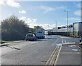
2
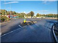
Cul-de-sac on Foul Lane
Although Foul Lane runs through to Butts Lane, it is blocked off to through motor traffic beyond the roundabout, whilst remaining a useful through route for cyclists. The car park for an abandoned park and ride scheme (closed 2023) lies to the right of the roundabout.
Image: © Oliver Dixon
Taken: 22 Oct 2024
0.05 miles
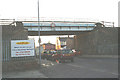
3

Foul Lane
The direct railway line from Southport to Manchester via Blowick crossed the road immediately beyond the bridge over the drain in the foreground.
Beyond is the bridge carrying the present Southport to Manchester railway via Meols Cop. It is of comparatively recent construction (1911) having been built to connect the Barton branch to the direct Manchester line at Pool Hey junction.
Foul Lane is blocked off to through motor traffic but does form a useful route for cyclists.
Image: © Oliver Dixon
Taken: 22 Oct 2024
0.11 miles
4
Site of Blowick Station
View eastward, towards Wigan and Manchester; ex-L&Y Manchester - Wigan - Southport line. Although this station was closed to passengers as long ago as 25/9/39 (goods 7/9/64), all trains have been run into Southport over the loop through Meols Cop since 6/65 instead of this direct line. The bridge in the distance carried the branch line from Altcar via Barton.
Image: © Ben Brooksbank
Taken: 26 Aug 1964
0.12 miles
5

End of Sainsbury's supermarket
A railway embankment on the Barton Branch railway formerly spanned the direct Southport to Manchester railway by a bridge (out of sight to the right) and passed through what is now Sainsbury's supermarket on the Meols Cop Retail Park. The railway was closed for passengers in 1938, although the track was not removed until 1964 after which the embankment and bridge were removed and all traces obliterated.
Image: © Oliver Dixon
Taken: 22 Oct 2024
0.15 miles
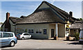
6
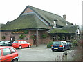
The Thatch & Thistle
Meols Cop Road, Blowick.
Image: © Peter Hodge
Taken: 22 Jan 2006
0.16 miles
8
Foul Lane
In the 1950s, Foul Lane was a cinder road alongside a railway embankment and was the closest to home in Scarisbrick New Road that could remotely be called a country walk.
To the right, Sainsbury's supermarket and other business premises on the Meols Cop Retail Park stand on the site of a former railway embankment, built for the Liverpool, Southport and Preston railway in 1887. The railway was closed for passengers in 1938, although the track was not removed until 1964 after which the embankment was removed and all traces of it obliterated.
Image: © Oliver Dixon
Taken: 22 Oct 2024
0.19 miles
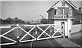
9
No problem for the buses
The headroom on the bridge leading to Blowick bus sheds leaves ample room for double-deckers.
Image: © David Long
Taken: 11 Jan 2006
0.22 miles
10

The Display Hoarding - Meols Cop Retail Park
Situated at the entrance from Meols Cop Road, the list of traders has most of the usual suspects. In the distance is Meols Cop High School
Image: © K A
Taken: 20 Jul 2012
0.24 miles