IMAGES TAKEN NEAR TO
Westmoreland Road, SOUTHPORT, PR8 6NX
Introduction
This page details the photographs taken nearby to Westmoreland Road, PR8 6NX by members of the Geograph project.
The Geograph project started in 2005 with the aim of publishing, organising and preserving representative images for every square kilometre of Great Britain, Ireland and the Isle of Man.

There are currently over 7.5m images from over14,400 individuals and you can help contribute to the project by visiting https://www.geograph.org.uk
Image Map
Images are licensed for reuse under creativecommons.org/licenses/by-sa/2.0
Notes
- Clicking on the map will re-center to the selected point.
- The higher the marker number, the further away the image location is from the centre of the postcode.
Image Listing (14 Images Found)
Images are licensed for reuse under creativecommons.org/licenses/by-sa/2.0
Image
Details
Distance
1
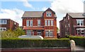
Houses on Scarisbrick New Road
There is a variety of houses in this area on the outskirts of Southport. Most of the old Victorian large family houses have been converted to flats.
Image: © Gerald England
Taken: 10 Jul 2009
0.08 miles
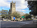
2
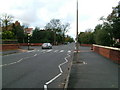
Scarisbrick New Road
Looking along Scarisbrick New Road, the main route into the town from the east.
Image: © Michael Williamson
Taken: 28 Oct 2008
0.09 miles
3
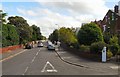
Lethbridge Road
Off Scarisbrick New Road.
Image: © Gerald England
Taken: 10 Jul 2009
0.12 miles
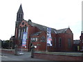
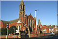

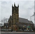
8
The Church Of St Philip & St Paul With Wesley, Southport
Scarisbrick New Road, Southport.
Image: © David Dixon
Taken: 25 Sep 2010
0.17 miles
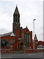
9
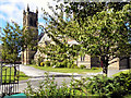
The Church Of St Philip & St Paul With Wesley
Scarisbrick New Road, Southport.
Image: © David Dixon
Taken: 25 Sep 2010
0.17 miles