IMAGES TAKEN NEAR TO
Hart Street, SOUTHPORT, PR8 6BP
Introduction
This page details the photographs taken nearby to Hart Street, PR8 6BP by members of the Geograph project.
The Geograph project started in 2005 with the aim of publishing, organising and preserving representative images for every square kilometre of Great Britain, Ireland and the Isle of Man.

There are currently over 7.5m images from over14,400 individuals and you can help contribute to the project by visiting https://www.geograph.org.uk
Image Map (Loading...)


Getting Data...Please wait
Leaflet Map data © OpenStreetMap
Images are licensed for reuse under creativecommons.org/licenses/by-sa/2.0
Notes
- Clicking on the map will re-center to the selected point.
- The higher the marker number, the further away the image location is from the centre of the postcode.
Image Listing (15 Images Found)
Images are licensed for reuse under creativecommons.org/licenses/by-sa/2.0
Image
Details
Distance
2
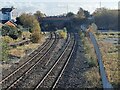
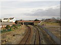
Site of St Luke's station
Seen from the Windsor Road footbridge. St Luke's was a station (open 1883 to 1968) a short way from the town centre which served three railway routes - to Preston, the Barton branch and the direct line to Manchester via Blowick. The first two passed under the bridge in view, the latter under a further span of the bridge to the right (south). The only service now passing along this line is to Manchester via Meols Cop.
Image: © Oliver Dixon
Taken: 22 Oct 2024
0.05 miles
3
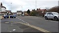
St Lukes Road, Southport
The junction of Kensington Road with St Lukes Road in Southport.
Image: © Peter Mackenzie
Taken: 16 Mar 2017
0.05 miles
5
Railway line to and from Wigan, Southport
Looking from a footbridge crossing the tracks along the railway line between Southport and Wigan. The tracks are used by local stopping services carrying passengers to destinations in the North West of England, to Wigan and beyond. The road bridge in the distance carries Rose Hill over the railway lines.
Image: © Graham Robson
Taken: 24 Mar 2018
0.12 miles
6
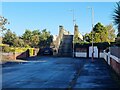
Steps up to the Windsor Road footbridge
Looking from the western (Hampton Road) end at the footbridge which spans the Southport to Manchester line. A bridge on this site was part of the infrastructure of the temporary Windsor Road station (1878-1882). Indeed judging from the state of the ironwork and the wear on the stone steps, this might well be the original unrenovated bridge from that era.
Image: © Oliver Dixon
Taken: 22 Oct 2024
0.14 miles
7
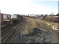
Railway line to and from Southport
Looking down from a footbridge onto the railway line passing through a residential area close to Southport town centre.
Image: © Graham Robson
Taken: 24 Mar 2018
0.14 miles
8
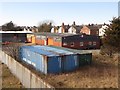
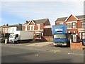
Industrial building off Windsor Road, Southport
An industrial building located between railway land and the back of a row of terraced houses. The site is accessed from Windsor Road and appears to belong to the Southport Bacon Company.
Image: © Graham Robson
Taken: 24 Mar 2018
0.15 miles
9
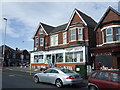
Business premises, Kensington Road, Southport
A large shop fitting business "Kiddie Shop Fitters" is based on this generally residential street in Southport. Hidden behind the houses, and accessed through the gap between them, is a large warehouse used by the business.
Image: © Graham Robson
Taken: 24 Mar 2018
0.16 miles
10
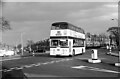
Leyland Atlantean demonstrator, Southport ? 1966
It was common practice for the large vehicle manufacturers, when a new model was just on the market, to have one available for operators to have on loan to evaluate. KTD 551C was just such a vehicle and is seen here on loan to Southport Corporation.
This is one of a series of views featuring buses in the 60s, 70s, and 80s.
http://www.geograph.org.uk/search.php?i=2114547&displayclass=slide
Image: © Alan Murray-Rust
Taken: 26 Feb 1966
0.16 miles