IMAGES TAKEN NEAR TO
The Ferns, PRESTON, PR5 5QT
Introduction
This page details the photographs taken nearby to The Ferns, PR5 5QT by members of the Geograph project.
The Geograph project started in 2005 with the aim of publishing, organising and preserving representative images for every square kilometre of Great Britain, Ireland and the Isle of Man.

There are currently over 7.5m images from over14,400 individuals and you can help contribute to the project by visiting https://www.geograph.org.uk
Image Map
Images are licensed for reuse under creativecommons.org/licenses/by-sa/2.0
Notes
- Clicking on the map will re-center to the selected point.
- The higher the marker number, the further away the image location is from the centre of the postcode.
Image Listing (7 Images Found)
Images are licensed for reuse under creativecommons.org/licenses/by-sa/2.0
Image
Details
Distance
1
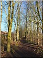
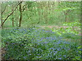
A woodland walk
Created as part of the development of the Walton Park housing estate, this is a nice woodland walk from the pond to Old Tram Road. It falls within the area of the proposed South Ribble Central Park https://web.archive.org/web/20151005072030/http://www.southribble.gov.uk/sites/default/files/CentralparkMasterplan.pdf (pdf).
Image: © Adam C Snape
Taken: 27 Dec 2015
0.13 miles
2
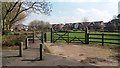
Walton Park Garden
This pocket park is viewed from where the Old Tram Road crosses Hennal Lane
Image: © Paul Collins
Taken: 14 Apr 2018
0.16 miles
3
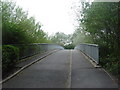
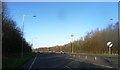
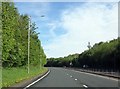
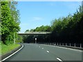
Footbridge over A6 near Dog Kennel Wood
Image: © Margaret Clough
Taken: 8 May 2006
0.21 miles