IMAGES TAKEN NEAR TO
Robin Hey, LEYLAND, PR26 7UL
Introduction
This page details the photographs taken nearby to Robin Hey, PR26 7UL by members of the Geograph project.
The Geograph project started in 2005 with the aim of publishing, organising and preserving representative images for every square kilometre of Great Britain, Ireland and the Isle of Man.

There are currently over 7.5m images from over14,400 individuals and you can help contribute to the project by visiting https://www.geograph.org.uk
Image Map
Images are licensed for reuse under creativecommons.org/licenses/by-sa/2.0
Notes
- Clicking on the map will re-center to the selected point.
- The higher the marker number, the further away the image location is from the centre of the postcode.
Image Listing (14 Images Found)
Images are licensed for reuse under creativecommons.org/licenses/by-sa/2.0
Image
Details
Distance
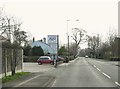
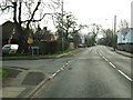
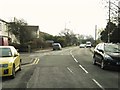
2
Dunkirk Lane at the junction with The Orchards
Image: © Ann Cook
Taken: 19 Mar 2011
0.15 miles
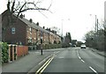
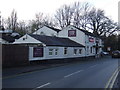
3
20 to 25 The Orchard
New housing built in the same format as to the ones next to them. The site which was 2 small bungalows with gardens, will eventually have another 19 houses "squeezed" on to it, made up of detached, semis and another row of terraced
Image: © Alexander P Kapp
Taken: 15 Jul 2007
0.16 miles
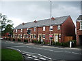
5
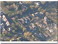
Rural-Urban fringe development
Aerial shot from about 600ft above Dunkirk Lane
Image: © Roger Whittleston
Taken: Unknown
0.17 miles

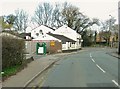
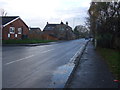
10
Dunkirk Lane at the junction with Paradise Lane
Image: © Ann Cook
Taken: 19 Mar 2011
0.23 miles