IMAGES TAKEN NEAR TO
Peel Hall Street, PRESTON, PR1 6QQ
Introduction
This page details the photographs taken nearby to Peel Hall Street, PR1 6QQ by members of the Geograph project.
The Geograph project started in 2005 with the aim of publishing, organising and preserving representative images for every square kilometre of Great Britain, Ireland and the Isle of Man.

There are currently over 7.5m images from over14,400 individuals and you can help contribute to the project by visiting https://www.geograph.org.uk
Image Map
Images are licensed for reuse under creativecommons.org/licenses/by-sa/2.0
Notes
- Clicking on the map will re-center to the selected point.
- The higher the marker number, the further away the image location is from the centre of the postcode.
Image Listing (29 Images Found)
Images are licensed for reuse under creativecommons.org/licenses/by-sa/2.0
Image
Details
Distance
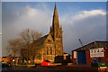
1
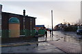
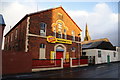
Mosque on the corner of Peel Hall Street
In the distance along Deepdale Mill Street on the right, you can see Preston North End's football stadium. The ground is wet from a recent very sharp hail shower.
Image: © Bill Boaden
Taken: 18 Feb 2012
0.07 miles
2
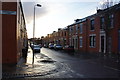
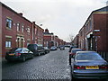
Castleton Road, Preston
Traditional residential street in the Deepdale area. It is experiencing sun after showers.
Image: © Bill Boaden
Taken: 18 Feb 2012
0.09 miles
3
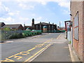
Deepdale Mill Street level crossing
Mid-19th-century changes to the railway layout in northern Preston left the original terminus of the Preston & Longridge Railway on a short branch, where it survived as a coal yard until the 1990s. Although the line has since been disused, the rails still remain in situ for most of the way and are seen here crossing Deepdale Mill Street on the level. The later extension to Maudlands passed under this road just to the right of the picture and ran between the mosque and the terraced housing in the background.
Image: © A-M-Jervis
Taken: 9 Aug 2007
0.11 miles
4
Hailstorm on Golbourne Street
The storm made the ground white in a matter of seconds. This is an area of social housing which is newer than the surrounding neighbourhood.
Image: © Bill Boaden
Taken: 18 Feb 2012
0.12 miles
5
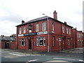
Former Primitive Methodist Sunday School
It dates from 1883 but is now successfully used as commercial premises. Behind is the spire of St Luke's Church which also now has an alternative use.
Image: © Bill Boaden
Taken: 18 Feb 2012
0.13 miles
7
The New Deepdale, St Georges Road, Preston
Image: © Alexander P Kapp
Taken: 6 Aug 2008
0.17 miles
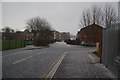
8
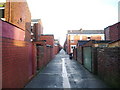
Back street
This back street runs parallel Holmrook Road
Image: © Alexander P Kapp
Taken: 16 Jan 2008
0.17 miles
9
Former St Luke's Church
This is now known as Bridge House and is operated by Eaves Brook, a provider of social housing.
Image: © Bill Boaden
Taken: 18 Feb 2012
0.18 miles
10
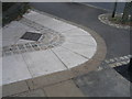
Boundary markers in Deepdale Road
The Preston and Longridge railway eventually became jointly owned by the London & North Western and Lancashire & Yorkshire Railway Companies. The line passed under Deepdale Road near the junction with Barrow Road but the railway company owned a small piece of land at the road junction behind their bridge parapet and the outer row of stones, suitably initialled, were laid to define their property boundary. The four grey panels in the inner vee, inscribed with fish, flowers and castle sketches, are a recent addition as part of a community project to improve the appearance of the area.
Image: © A-M-Jervis
Taken: 9 Aug 2007
0.18 miles