IMAGES TAKEN NEAR TO
Bleasdale Street East, PRESTON, PR1 5DB
Introduction
This page details the photographs taken nearby to Bleasdale Street East, PR1 5DB by members of the Geograph project.
The Geograph project started in 2005 with the aim of publishing, organising and preserving representative images for every square kilometre of Great Britain, Ireland and the Isle of Man.

There are currently over 7.5m images from over14,400 individuals and you can help contribute to the project by visiting https://www.geograph.org.uk
Image Map
Images are licensed for reuse under creativecommons.org/licenses/by-sa/2.0
Notes
- Clicking on the map will re-center to the selected point.
- The higher the marker number, the further away the image location is from the centre of the postcode.
Image Listing (27 Images Found)
Images are licensed for reuse under creativecommons.org/licenses/by-sa/2.0
Image
Details
Distance
1
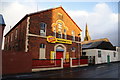
Former Primitive Methodist Sunday School
It dates from 1883 but is now successfully used as commercial premises. Behind is the spire of St Luke's Church which also now has an alternative use.
Image: © Bill Boaden
Taken: 18 Feb 2012
0.04 miles
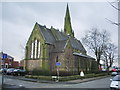
2
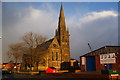
Former St Luke's Church
This is now known as Bridge House and is operated by Eaves Brook, a provider of social housing.
Image: © Bill Boaden
Taken: 18 Feb 2012
0.04 miles
3
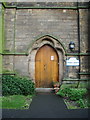
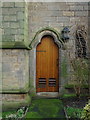
Bridge House (St Luke's Church), Doorway
Image: © Alexander P Kapp
Taken: 28 Jan 2008
0.06 miles
4
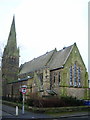
Bridge House (St Luke's Church)
Now converted in to housing
Image: © Alexander P Kapp
Taken: 28 Jan 2008
0.06 miles
5
Bridge House (St Luke's Church), Doorway
Image: © Alexander P Kapp
Taken: 28 Jan 2008
0.07 miles
7
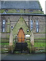
Bridge House (St Luke's Church), Porch
Image: © Alexander P Kapp
Taken: 28 Jan 2008
0.07 miles
8
Deepdale Mill Street level crossing
Mid-19th-century changes to the railway layout in northern Preston left the original terminus of the Preston & Longridge Railway on a short branch, where it survived as a coal yard until the 1990s. Although the line has since been disused, the rails still remain in situ for most of the way and are seen here crossing Deepdale Mill Street on the level. The later extension to Maudlands passed under this road just to the right of the picture and ran between the mosque and the terraced housing in the background.
Image: © A-M-Jervis
Taken: 9 Aug 2007
0.09 miles
9
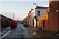
Andrew Street
Side street off Ribbleton Lane with distant views of Preston North End's ground at Deepdale.
Image: © Bill Boaden
Taken: 18 Feb 2012
0.10 miles
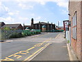
10
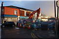
Ribbleton Lane is closed
Road works are being undertaken and there is a diversion along Fletcher Road.
Image: © Bill Boaden
Taken: 18 Feb 2012
0.11 miles