IMAGES TAKEN NEAR TO
Fletcher Road, PRESTON, PR1 5AD
Introduction
This page details the photographs taken nearby to Fletcher Road, PR1 5AD by members of the Geograph project.
The Geograph project started in 2005 with the aim of publishing, organising and preserving representative images for every square kilometre of Great Britain, Ireland and the Isle of Man.

There are currently over 7.5m images from over14,400 individuals and you can help contribute to the project by visiting https://www.geograph.org.uk
Image Map (Loading...)


Getting Data...Please wait
Leaflet Map data © OpenStreetMap
Images are licensed for reuse under creativecommons.org/licenses/by-sa/2.0
Notes
- Clicking on the map will re-center to the selected point.
- The higher the marker number, the further away the image location is from the centre of the postcode.
Image Listing (34 Images Found)
Images are licensed for reuse under creativecommons.org/licenses/by-sa/2.0
Image
Details
Distance
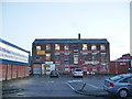
1
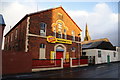
Former Primitive Methodist Sunday School
It dates from 1883 but is now successfully used as commercial premises. Behind is the spire of St Luke's Church which also now has an alternative use.
Image: © Bill Boaden
Taken: 18 Feb 2012
0.13 miles
2
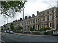
58-102 Deepdale Road, Preston
Aka Stephenson Terrace. By George Mould, 1839-50. Grade II listed.
Image: © Stephen Richards
Taken: 12 Jun 2013
0.15 miles
3
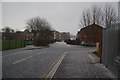
Hailstorm on Golbourne Street
The storm made the ground white in a matter of seconds. This is an area of social housing which is newer than the surrounding neighbourhood.
Image: © Bill Boaden
Taken: 18 Feb 2012
0.15 miles
5
"Superpet Warehouse", Crook Street, Preston
They could soon run out of space for putting up a new sign
Image: © Alexander P Kapp
Taken: 16 Jan 2008
0.16 miles
6
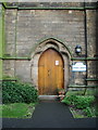
Bridge House (St Luke's Church), Doorway
Image: © Alexander P Kapp
Taken: 28 Jan 2008
0.16 miles
7
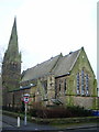
Bridge House (St Luke's Church)
Now converted in to housing
Image: © Alexander P Kapp
Taken: 28 Jan 2008
0.16 miles
8
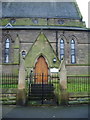
Bridge House (St Luke's Church), Porch
Image: © Alexander P Kapp
Taken: 28 Jan 2008
0.16 miles
9
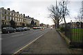
Deepdale Road by the Deepdale Enclosure
The green space on the right is a longstanding area of common land, and fine Victorian houses were erected around it, such as Stephenson Terrace on the left. It is now a Conservation Area.
Image: © Bill Boaden
Taken: 18 Feb 2012
0.17 miles
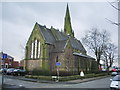
10
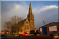
Former St Luke's Church
This is now known as Bridge House and is operated by Eaves Brook, a provider of social housing.
Image: © Bill Boaden
Taken: 18 Feb 2012
0.17 miles