IMAGES TAKEN NEAR TO
Main Road, RYDE, PO33 4DH
Introduction
This page details the photographs taken nearby to Main Road, PO33 4DH by members of the Geograph project.
The Geograph project started in 2005 with the aim of publishing, organising and preserving representative images for every square kilometre of Great Britain, Ireland and the Isle of Man.

There are currently over 7.5m images from over14,400 individuals and you can help contribute to the project by visiting https://www.geograph.org.uk
Image Map
Images are licensed for reuse under creativecommons.org/licenses/by-sa/2.0
Notes
- Clicking on the map will re-center to the selected point.
- The higher the marker number, the further away the image location is from the centre of the postcode.
Image Listing (60 Images Found)
Images are licensed for reuse under creativecommons.org/licenses/by-sa/2.0
Image
Details
Distance
1
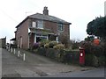
Havenstreet: post office and postbox № PO33 86
This post office was open 9-1 Monday to Saturday, before closing permanently on 13 February 2008. It was closed today, for some reason.
Image: © Chris Downer
Taken: 5 Feb 2008
0.03 miles
2
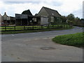
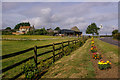
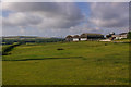
Coppidhall Farm
Coppidhall Farm on the corner of Haven Street
Image: © Shaun Ferguson
Taken: 30 Oct 2008
0.07 miles
3
Havenstreet: Coppidhall Farm
Looking into the sun at Coppidhall Farm, while various aircraft produce lines in the sky.
Image: © Chris Downer
Taken: 9 Feb 2008
0.08 miles
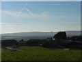
4
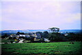
Coppidhall Farm
Taken from the hill to the north containing the war memorial and trig point and looking down on the farm and beyond to the downs. The footpath exits the field to the right of the cows at the junction of Main Road and Firestone Copse Road.
Image: © Simon Carey
Taken: 19 Aug 2007
0.08 miles
5
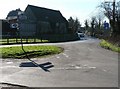
Coppid Hall Farm
Farm on the outskirts of Havenstreet.
Image: © Ian Capper
Taken: 16 Jul 2009
0.09 miles
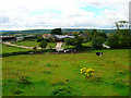
6
Coppidhall Farm
A view from the trig point on a small hill. The village of Havenstreet is beyond the farm.
Image: © Bill Boaden
Taken: 12 Aug 1999
0.09 miles
7
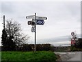
Havenstreet: road junction
The junction to the north of the village, with the road to Ryde left of picture and Image to the right. The Isle of Wight cycleway route is denoted by signs depicting a cycle within an Isle of Wight-shaped patch.
Image: © Chris Downer
Taken: 9 Feb 2008
0.09 miles
9
Coppid Hall Farm
Farm on the outskirts of Havenstreet.
Image: © Ian Capper
Taken: 16 Jul 2009
0.10 miles
10
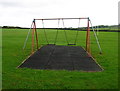
Swings, Havenstreet Recreation Ground
The sloping hillside causes some strange angles and alignments. The recreation ground is bounded by Church Lane to the west and the footpath to Rowlands Lane to the south.
Image: © Simon Carey
Taken: 19 Aug 2007
0.10 miles