IMAGES TAKEN NEAR TO
Marshall Avenue, BOGNOR REGIS, PO21 2TW
Introduction
This page details the photographs taken nearby to Marshall Avenue, PO21 2TW by members of the Geograph project.
The Geograph project started in 2005 with the aim of publishing, organising and preserving representative images for every square kilometre of Great Britain, Ireland and the Isle of Man.

There are currently over 7.5m images from over14,400 individuals and you can help contribute to the project by visiting https://www.geograph.org.uk
Image Map
Images are licensed for reuse under creativecommons.org/licenses/by-sa/2.0
Notes
- Clicking on the map will re-center to the selected point.
- The higher the marker number, the further away the image location is from the centre of the postcode.
Image Listing (33 Images Found)
Images are licensed for reuse under creativecommons.org/licenses/by-sa/2.0
Image
Details
Distance
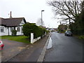
1
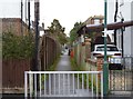
Down my alley
A public footpath cuts through from the Aldwick area of Bognor to Linden Road and the Cemetery, This photograph is where it connects the two branches of Marshall Avenue.
Image: © Jeff Gogarty
Taken: 10 Mar 2018
0.07 miles
2
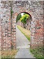
Arch and old wall, off Holly Atterton Walk
It leads to Servite Close. The old walls interested me and a wondered what was behind them and it turns out it is just back gardens of Highlands Avenue.
Bognor Regis has several walks leading between the streets.
I have been informed that these walls used to enclose a Nunnery of a closed order. There is a plaque at a small cemetery on the corner of Servite Close and Hawthorn Road honouring 25 sisters of the Servite Order that are buried there.
Image: © Jeff Gogarty
Taken: 6 Jun 2020
0.08 miles
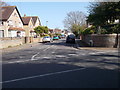
3
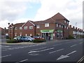
Bognor Regis, convenience store
Co-operative Food, on Hawthorn Road.
Image: © Mike Faherty
Taken: 18 Mar 2014
0.12 miles
4
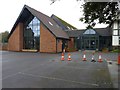
Bognor Regis Baptist Church - Victoria Drive
Image: © Betty Longbottom
Taken: 15 Apr 2015
0.12 miles
5
Bognor Regis Baptist Church - Victoria Drive
Image: © Jeff Gogarty
Taken: 10 Mar 2018
0.12 miles
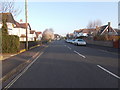
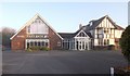
9
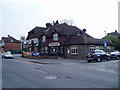
The Wheatsheaf, Hawthorn Road
Traditional styled pub in residential area built just before second world war.
Image: © Peter Holmes
Taken: 14 Apr 2012
0.15 miles
10
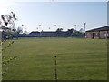
Bognor Regis Croquet & Lawn Tennis Club - Nyewood Lane
Image: © Betty Longbottom
Taken: 15 Apr 2015
0.15 miles