IMAGES TAKEN NEAR TO
Selhurst Park, Halnaker, CHICHESTER, PO18 0LZ
Introduction
This page details the photographs taken nearby to PO18 0LZ by members of the Geograph project.
The Geograph project started in 2005 with the aim of publishing, organising and preserving representative images for every square kilometre of Great Britain, Ireland and the Isle of Man.

There are currently over 7.5m images from over14,400 individuals and you can help contribute to the project by visiting https://www.geograph.org.uk
Image Map
Images are licensed for reuse under creativecommons.org/licenses/by-sa/2.0
Notes
- Clicking on the map will re-center to the selected point.
- The higher the marker number, the further away the image location is from the centre of the postcode.
Image Listing (14 Images Found)
Images are licensed for reuse under creativecommons.org/licenses/by-sa/2.0
Image
Details
Distance

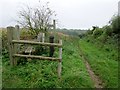
2
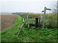
Redundant stile
Monarch's Way follows public footpath 398 adjacent to ploughed field. OS map appears to show the right of way passing through the corn field to the east of the path. Another example of realignment with actuality.
Image: © Peter Holmes
Taken: 14 Oct 2017
0.16 miles
3
Monarch?s Way
On the Monarch’s Way at Selhurst Park. In the field ahead to the left a tractor was out spraying. This led to an abrupt halt to the planned walk and an alternative direction being taken.
Image: © Chris Thomas-Atkin
Taken: 30 Mar 2021
0.16 miles
4
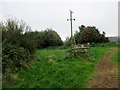
Overhead power line junction
Track between row of trees leading to Middle Barn Farm.
Image: © Peter Holmes
Taken: 14 Oct 2017
0.16 miles
5
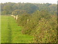
Selhurst Park
Grassy footpath following a hedgerow and wire fence near to Eartham Wood.
Image: © Colin Smith
Taken: 9 Oct 2010
0.17 miles
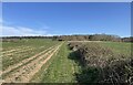
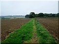
6
Path between ploughed fields
Monarch's Way follows public footpath 398 south. OS map appears to show the right of way passing through the corn field to the east of the path. Another example of realignment with actuality. Buildings at Middle Barn can be seen in the distance.
Image: © Peter Holmes
Taken: 14 Oct 2017
0.18 miles
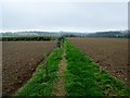
7
View towards Eartham Wood
Monarch's Way follows public footpath 398 towards A285 and Ides Common.
Image: © Peter Holmes
Taken: 14 Oct 2017
0.19 miles
8
Footpath between ploughed fields
Monarch's Way follows public footpath 398 towards Selhurst Park.
Image: © Peter Holmes
Taken: 14 Oct 2017
0.20 miles
9
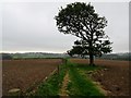
Lone oak tree
Monarch's Way follows public footpath 398 south between ploughed fields.
Image: © Peter Holmes
Taken: 14 Oct 2017
0.21 miles
10
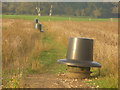
Bird Feeders, Selhurst Park
A line of distinctive pheasant feeders, with a couple of pheasants, on the South Downs near Eartham.
Image: © Colin Smith
Taken: 9 Oct 2010
0.22 miles