IMAGES TAKEN NEAR TO
Staddiscombe, PLYMOUTH, PL9 9LY
Introduction
This page details the photographs taken nearby to PL9 9LY by members of the Geograph project.
The Geograph project started in 2005 with the aim of publishing, organising and preserving representative images for every square kilometre of Great Britain, Ireland and the Isle of Man.

There are currently over 7.5m images from over14,400 individuals and you can help contribute to the project by visiting https://www.geograph.org.uk
Image Map
Images are licensed for reuse under creativecommons.org/licenses/by-sa/2.0
Notes
- Clicking on the map will re-center to the selected point.
- The higher the marker number, the further away the image location is from the centre of the postcode.
Image Listing (10 Images Found)
Images are licensed for reuse under creativecommons.org/licenses/by-sa/2.0
Image
Details
Distance
1
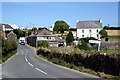
Staddiscombe
Staddiscombe is a hamlet on the hilltop just outside the Plymouth urban area.
Image: © Tony Atkin
Taken: 26 Jul 2008
0.01 miles
2

Barns, Staddiscombe
These farm buildings at Leyford Farm are seen from Bovisand Road.
Image: © Derek Harper
Taken: 1 Jul 2011
0.05 miles
3
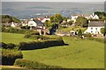
South Hams : Staddiscombe Scenery
A view towards Staddiscombe with the countryside surroundings.
Image: © Lewis Clarke
Taken: 25 Jul 2012
0.05 miles
4
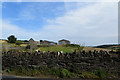
Near Staddiscombe
Drystone wall and farm buildings.
Image: © Robert Ashby
Taken: 4 Aug 2015
0.05 miles
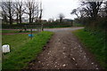
5

Erme-Plym Trail
This is public footpath 23,just after leaving Staddiscombe.
Image: © jeff collins
Taken: 26 Mar 2014
0.08 miles
6
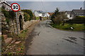
Staddiscombe Road,Staddiscombe
The Erme-Plym Trail follows the road down hill and around the village for a while before crossing more fields.
Image: © jeff collins
Taken: 26 Mar 2014
0.16 miles
7
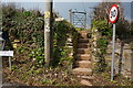
Steps and Kissing Gate
Erme-Plym Trail from the top of Staddiscombe Road the trail goes up the steps in the direction of Radford Woods.
Image: © jeff collins
Taken: 26 Mar 2014
0.17 miles
8

Staddiscombe Woods
Cloaking the hillside to the west of the Goosewell housing estate, the deciduous woods act as a green lung to the area and offer numerous footpaths for walking.
Image: © Gwyn Jones
Taken: 21 Sep 2005
0.17 miles
9
Approaching Staddiscombe
The track to the left goes to Courtgates, the path goes right then sharp left over a granite stile.
Image: © jeff collins
Taken: 26 Mar 2014
0.22 miles
10
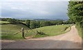
Track junction, Staddiscombe
A view on the Erme-Plym Trail, following a footpath between Hooe and Staddiscombe. The track leads to Courtgates. On the left are Image
Image: © Derek Harper
Taken: 1 Jul 2011
0.23 miles