IMAGES TAKEN NEAR TO
Furzehatt Road, PLYMOUTH, PL9 9JU
Introduction
This page details the photographs taken nearby to Furzehatt Road, PL9 9JU by members of the Geograph project.
The Geograph project started in 2005 with the aim of publishing, organising and preserving representative images for every square kilometre of Great Britain, Ireland and the Isle of Man.

There are currently over 7.5m images from over14,400 individuals and you can help contribute to the project by visiting https://www.geograph.org.uk
Image Map
Images are licensed for reuse under creativecommons.org/licenses/by-sa/2.0
Notes
- Clicking on the map will re-center to the selected point.
- The higher the marker number, the further away the image location is from the centre of the postcode.
Image Listing (62 Images Found)
Images are licensed for reuse under creativecommons.org/licenses/by-sa/2.0
Image
Details
Distance
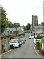
1
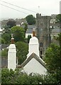
Chimneys and church tower, Plymstock
The chimneys belong to Burrow Farmhouse which dates from around 1600, Listed grade II. The rounded chimney stacks are typical of the area.
Image: © Alan Murray-Rust
Taken: 28 Jun 2023
0.07 miles
3
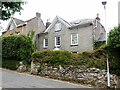
Louville and Marchant House, Church Road, Plymstock
Both houses date from the 18th century and are Listed Grade II. Of interest are the Venetian window in the gable of Louville and the traditional slate-hanging on Marchant House.
Image: © Alan Murray-Rust
Taken: 28 Jun 2023
0.08 miles
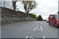
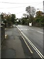
5
Church Road, Plymstock
Part of the old village. Many of the local roads, like this, are not provided with footways.
Image: © Alan Murray-Rust
Taken: 28 Jun 2023
0.12 miles
8
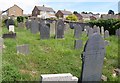
Graveyard, St Mary And All Saints, Plymstock
The graveyard straddles a northing gridline; this is part of the southern side, overlooked by houses on Dolphin Close.
Image: © Derek Harper
Taken: 1 Jul 2011
0.13 miles
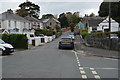
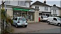
9
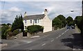
Listed house, Plymstock
Benhay, at the junction of Furzehatt Road with Holland Road (left), is an early C19 detached house http://www.britishlistedbuildings.co.uk/en-473450-benhay-100-plymouth .
Image: © Derek Harper
Taken: 1 Jul 2011
0.14 miles
10
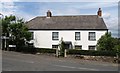
Listed house, Plymstock
Just across the top of Holland Road from Image is the earlier (late C18) Furzehatt House http://www.britishlistedbuildings.co.uk/en-473451-furzehatt-house-102-plymouth , here seen across Furzehatt Road from the junction with Goosewell Road.
Image: © Derek Harper
Taken: 1 Jul 2011
0.14 miles