IMAGES TAKEN NEAR TO
Leyford Lane, PLYMOUTH, PL9 0DG
Introduction
This page details the photographs taken nearby to Leyford Lane, PL9 0DG by members of the Geograph project.
The Geograph project started in 2005 with the aim of publishing, organising and preserving representative images for every square kilometre of Great Britain, Ireland and the Isle of Man.

There are currently over 7.5m images from over14,400 individuals and you can help contribute to the project by visiting https://www.geograph.org.uk
Image Map
Images are licensed for reuse under creativecommons.org/licenses/by-sa/2.0
Notes
- Clicking on the map will re-center to the selected point.
- The higher the marker number, the further away the image location is from the centre of the postcode.
Image Listing (9 Images Found)
Images are licensed for reuse under creativecommons.org/licenses/by-sa/2.0
Image
Details
Distance
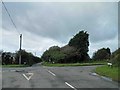
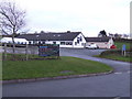
2
Ridge Cross
Fordbrook Lane at Ridge Cross, with Wembury Road cutting across and Leyford Lane straight ahead.
Image: © Shaun Ferguson
Taken: 7 Aug 2010
0.14 miles
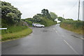
5
The Staddy
The Staddiscombe Social Club building is truly multi-purpose; serving the local community with entertainment and spiritual needs. The blue sign is for The Holy Family church which also uses the premises.
Image: © Jonathan Billinger
Taken: 28 Nov 2007
0.18 miles
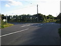
6
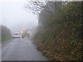
Hedge cutting in the mist on a minor road near Spriddlestone
Image: © Rod Allday
Taken: 29 Oct 2014
0.19 miles

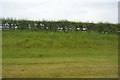
8
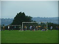
Staddiscombe Playing Fields
Occupying the ridge to the south of Plymstock, the windswept playing fields mark the edge of the city boundary.
Image: © Gwyn Jones
Taken: 11 Sep 2005
0.22 miles
9
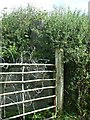
Wembury Trig
Any list of Geograph photographs should include the relevant Trig pillars. This that of Wembury Trig, now neglected and overgrown by the surrounding hedgerow..
Image: © Gwyn Jones
Taken: 17 Sep 2005
0.22 miles