IMAGES TAKEN NEAR TO
Steer Point, Brixton, PLYMOUTH, PL8 2DQ
Introduction
This page details the photographs taken nearby to PL8 2DQ by members of the Geograph project.
The Geograph project started in 2005 with the aim of publishing, organising and preserving representative images for every square kilometre of Great Britain, Ireland and the Isle of Man.

There are currently over 7.5m images from over14,400 individuals and you can help contribute to the project by visiting https://www.geograph.org.uk
Image Map (Loading...)


Getting Data...Please wait
Leaflet Map data © OpenStreetMap
Images are licensed for reuse under creativecommons.org/licenses/by-sa/2.0
Notes
- Clicking on the map will re-center to the selected point.
- The higher the marker number, the further away the image location is from the centre of the postcode.
Image Listing (16 Images Found)
Images are licensed for reuse under creativecommons.org/licenses/by-sa/2.0
Image
Details
Distance
1
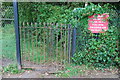
Kissing Gate
This Kissing Gate,is opposite Steer Point Brickworks,and the start of a footpath along the Estuary.
Image: © jeff collins
Taken: 7 Sep 2008
0.04 miles
2

Company Sign
This sign carries the name and logo of the company that own the Brickworks.
Image: © jeff collins
Taken: 7 Sep 2008
0.04 miles
3
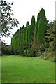
Formal Trees
A row of large Evergreens, possibly of the Juniperus family.Near the Brickworks.
Image: © jeff collins
Taken: 7 Sep 2008
0.07 miles

5
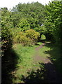
Former railway near Steer Point
Brixton Footpath 30 follows the former line of the Yealmpton Branch railway; see Image for a description.
Image: © Derek Harper
Taken: 1 Jul 2011
0.09 miles
6
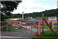
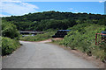
Steer Point Brickworks
This brickworks is owned by a European Company,and is one of the biggest enployers in this area.
Image: © jeff collins
Taken: 7 Sep 2008
0.10 miles
7
Former Steer Point Brickworks
See Image for a photo of the brickworks close to the time it closed. The buildings are now mostly gone. The quarry appears, from aerial images, not to have been infilled. Planning was granted in 2014 despite considerable local opposition.
Image: © Hugh Venables
Taken: 6 Jul 2019
0.10 miles
8
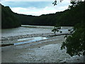
Mud Flats, Cofflete Creek
Meandering through tidal mudflats a freshwater outflow passes south through the lower reaches of Cofflete Creek, between Western and Wembury Woods.
Image: © Gwyn Jones
Taken: 17 Sep 2005
0.11 miles
9
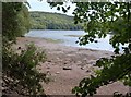
Tidal Inlet
A small inlet looking out on to,Mudbank Lake.
Image: © jeff collins
Taken: 7 Sep 2008
0.13 miles
10
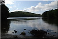
South Creek
A side creek of the Yealm estuary. On the far side is Crawl Wood.
Image: © Derek Harper
Taken: 1 Jul 2011
0.14 miles