IMAGES TAKEN NEAR TO
Plympton, PLYMOUTH, PL7 5AP
Introduction
This page details the photographs taken nearby to PL7 5AP by members of the Geograph project.
The Geograph project started in 2005 with the aim of publishing, organising and preserving representative images for every square kilometre of Great Britain, Ireland and the Isle of Man.

There are currently over 7.5m images from over14,400 individuals and you can help contribute to the project by visiting https://www.geograph.org.uk
Image Map
Images are licensed for reuse under creativecommons.org/licenses/by-sa/2.0
Notes
- Clicking on the map will re-center to the selected point.
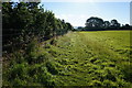
- The higher the marker number, the further away the image location is from the centre of the postcode.
Image Listing (34 Images Found)
Images are licensed for reuse under creativecommons.org/licenses/by-sa/2.0
Image
Details
Distance
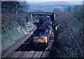
1
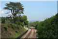
Sparkwell: towards Hemerdon Siding
Looking towards Moor Bridge. Just beyond is the switch into Hemerdon Siding. Trains here have just breasted the 2.7 mile climb at 1-42 from Plympton and now power on across Slade and Blatchford viaducts, still climbing through Ivybridge and Bittaford to reach the summit of the line at Wrangaton before descending to South Brent and on to Totnes
Image: © Martin Bodman
Taken: 2 Jun 2010
0.04 miles
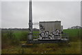
4
Communication Mast
In between the mainline and Sparkwell Footpath No4.
Image: © jeff collins
Taken: 9 Jul 2014
0.06 miles
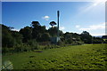
5
Sparkwell Footpath No4
Seen here looking East just after leaving Sparkwell Bridge. Just the other side of the fence is a small path used by rail engineers to gain access to the track hidden below the trees.
Image: © jeff collins
Taken: 9 Jul 2014
0.06 miles
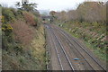
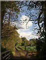
7
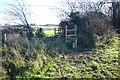
Stiles on Venton footpath
The footpath crosses a redundant green lane, with a stile on both sides. The lane crosses the railway over Moor Bridge (out of shot to the left).
Image: © Nigel Mole
Taken: 23 Nov 2007
0.08 miles
8
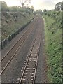
West Coast Railway Line
Looking East from Sparkwell Bridge. Looking in the opposite direction to; Image]
Image: © jeff collins
Taken: 28 Jun 2020
0.09 miles
9
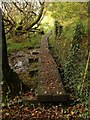
Duckboards at Hemerdon Siding
A reverse view of the scene in Image as Sparkwell Footpath 5 runs below Hemerdon Siding, just west of Image
Image: © Derek Harper
Taken: 5 Nov 2009
0.10 miles
10
Track to Parkside Farm
Seen from Ledgate Lane, between Langage and Beechwood Crosses, and passing through the belt of trees that runs alongside the lane from Sparkwell Bridge (across the nearby main railway line) northwards.
Image: © Derek Harper
Taken: 5 Nov 2009
0.12 miles