IMAGES TAKEN NEAR TO
Marsh Close, PLYMOUTH, PL6 8LB
Introduction
This page details the photographs taken nearby to Marsh Close, PL6 8LB by members of the Geograph project.
The Geograph project started in 2005 with the aim of publishing, organising and preserving representative images for every square kilometre of Great Britain, Ireland and the Isle of Man.

There are currently over 7.5m images from over14,400 individuals and you can help contribute to the project by visiting https://www.geograph.org.uk
Image Map
Images are licensed for reuse under creativecommons.org/licenses/by-sa/2.0
Notes
- Clicking on the map will re-center to the selected point.
- The higher the marker number, the further away the image location is from the centre of the postcode.
Image Listing (117 Images Found)
Images are licensed for reuse under creativecommons.org/licenses/by-sa/2.0
Image
Details
Distance
6
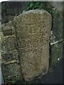
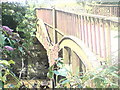
Old Boundary Marker on Longridge Road, Plymouth
Parish Boundary Marker between the west end of the parapet of Long Bridge and a stone wall on the east side of Longbridge Road, just off the B3416 Plymouth Road. Inscribed Egg / Buckland. Until 1939 this marked the boundary of Egg Buckland and Plympton St Mary parishes, after which Egg Buckland became part of Plymouth parish and borough.
Milestone Society National ID: DV_PLEX02apb
Image: © T Jenkinson
Taken: 31 Dec 2007
0.05 miles
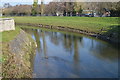
9
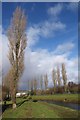
Poplars by the Plym
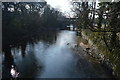
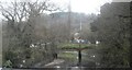
Paths beside the River Plym that are popular with dog-walkers.
Image: © Derek Harper
Taken: 29 Jan 2010
0.06 miles
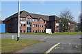
10
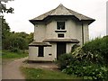
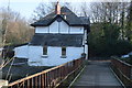
Weighbridge cottage
Immediately behind the cottage is the River Plym, and the path running past the cottage crosses the river on a former tramway bridge http://www.plymothiantransit.com/2008/09/plymothian-bridges-044-longbridge-road.html . The path links Coypool Road and Longbridge Road.
Image: © Derek Harper
Taken: 2 Oct 2009
0.06 miles