IMAGES TAKEN NEAR TO
Tamerton Road, PLYMOUTH, PL6 7BQ
Introduction
This page details the photographs taken nearby to Tamerton Road, PL6 7BQ by members of the Geograph project.
The Geograph project started in 2005 with the aim of publishing, organising and preserving representative images for every square kilometre of Great Britain, Ireland and the Isle of Man.

There are currently over 7.5m images from over14,400 individuals and you can help contribute to the project by visiting https://www.geograph.org.uk
Image Map
Images are licensed for reuse under creativecommons.org/licenses/by-sa/2.0
Notes
- Clicking on the map will re-center to the selected point.
- The higher the marker number, the further away the image location is from the centre of the postcode.
Image Listing (8 Images Found)
Images are licensed for reuse under creativecommons.org/licenses/by-sa/2.0
Image
Details
Distance
1
The Road to the Moors
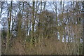
I could have called this "Waiting for the Bus at Roborough" which is what I was actually doing, but to me this scene is more reminiscent of the anticipation of Roborough Down just beyond those trees with views of Dartmoor beyond.
Image: © Tony Atkin
Taken: 26 Nov 2005
0.10 miles
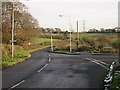
4
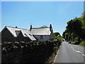
Drive to Roborough House Care Home
From Tamerton Road, at the spot where Image] was taken.
Image: © Derek Harper
Taken: 15 Feb 2014
0.17 miles
5

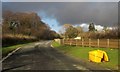
Pylon near Roborough
The trees behind the pylon on the right show the course of the Devonport Leat. View from Tamerton Road at the entrance to Roborough House Care Home.
Image: © Derek Harper
Taken: 15 Feb 2014
0.17 miles
8
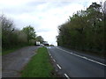
Tamerton Road
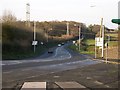
This used to be a narrow country lane but since industrial estates have been built next to it the Robourgh end of the road has been upgraded.
Image: © Tony Atkin
Taken: 26 Nov 2005
0.22 miles