IMAGES TAKEN NEAR TO
Channel Park Avenue, PLYMOUTH, PL3 6LJ
Introduction
This page details the photographs taken nearby to Channel Park Avenue, PL3 6LJ by members of the Geograph project.
The Geograph project started in 2005 with the aim of publishing, organising and preserving representative images for every square kilometre of Great Britain, Ireland and the Isle of Man.

There are currently over 7.5m images from over14,400 individuals and you can help contribute to the project by visiting https://www.geograph.org.uk
Image Map
Images are licensed for reuse under creativecommons.org/licenses/by-sa/2.0
Notes
- Clicking on the map will re-center to the selected point.
- The higher the marker number, the further away the image location is from the centre of the postcode.
Image Listing (11 Images Found)
Images are licensed for reuse under creativecommons.org/licenses/by-sa/2.0
Image
Details
Distance
1
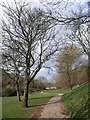
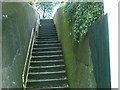
Lower Compton Park
The path leading up the valley from Image to Compton Vale.
Image: © Derek Harper
Taken: 27 Mar 2010
0.09 miles
2
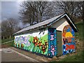
Colourful shed, Trefusis Gardens
Murals / graffiti have certainly brightened up this modest building by the car park for Lower Compton Park at the end of Trefusis Gardens.
Image: © Derek Harper
Taken: 27 Mar 2010
0.12 miles
3
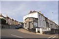
The Hair Room, Lipson Vale, Plymouth
This one storey business fills the angle between Efford Lane and Old Laira Road. It appears on the old maps of the city so was presumably built with the adjacent terrace
Image: © David Smith
Taken: 24 Jun 2018
0.19 miles
4
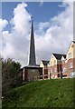
Spire Court, Plymouth
This spire is on top of a bank overlooking Blandford Road. The housing, flats for the elderly, was built in 2002 on the site of St Teresa's Roman Catholic church, which Cherry & Pevsner describe as a 1958 church, a small rectangle with an east clerestory-tower, but no mention of a fleche or spire. So I assume the spire, whose brickwork matches the flats, is contemporaneous with them and serves simply as an acknowledgment of the fact that a church stood here.
Update: thanks to John Haley, who tells me that he remembers the spire was part of the church of St Teresa, and so was not built to match the flats.
Image: © Derek Harper
Taken: 27 Mar 2010
0.20 miles
5
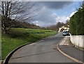
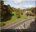
Trefusis Gardens, Plymouth
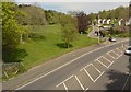
The road leads from Image up to a car park for Lower Compton Park (left), and is lined with houses on its east side only.
Image: © Derek Harper
Taken: 27 Mar 2010
0.21 miles
6
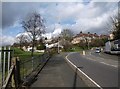
Old Laira Road, Plymouth
Taken from just north of Image, as the B3214 completes a double bend. On the left is Trefusis Gardens, the houses facing a recreation ground.
Image: © Derek Harper
Taken: 27 Mar 2010
0.22 miles
8
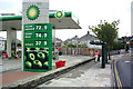
BP Garage, Compton
Owned by Safeways, this busy garage is situated in Higher Compton. This view is looking towards the mini roundabout where the road divides for Efford and Eggbuckland.
Image: © Mike Crowe
Taken: 15 May 2004
0.23 miles