IMAGES TAKEN NEAR TO
Harbour Terrace, BOSCASTLE, PL35 0AE
Introduction
This page details the photographs taken nearby to Harbour Terrace, PL35 0AE by members of the Geograph project.
The Geograph project started in 2005 with the aim of publishing, organising and preserving representative images for every square kilometre of Great Britain, Ireland and the Isle of Man.

There are currently over 7.5m images from over14,400 individuals and you can help contribute to the project by visiting https://www.geograph.org.uk
Image Map
Images are licensed for reuse under creativecommons.org/licenses/by-sa/2.0
Notes
- Clicking on the map will re-center to the selected point.
- The higher the marker number, the further away the image location is from the centre of the postcode.
Image Listing (382 Images Found)
Images are licensed for reuse under creativecommons.org/licenses/by-sa/2.0
Image
Details
Distance
1
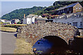
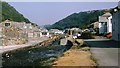
Lower Bridge, Boscastle
Boscastle is seen here on a fine day in the summer of 2001, three years before the disastrous flood that severely damaged the village including the lower bridge over the River Valency. The bridge was repaired but later replaced with a new bridge of a completely different design.
Image: © Stephen McKay
Taken: Unknown
0.01 miles
2
Boscastle from the coast path
Roof of Youth Hostel in the foreground.
Image: © Chris Gunns
Taken: 24 Sep 2013
0.01 miles
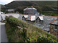
5
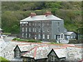
Harbour Terrace, Boscastle
A terrace of four three-storey houses contrasts to the cottages in the harbour area. The roof of the youth hostel is in the foreground.
Image: © Humphrey Bolton
Taken: 7 May 2009
0.01 miles
6
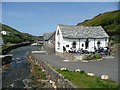
Reconstructed tea-room, Boscastle
This ancient building was destroyed by the flood of 2004, and has been rebuilt as closely as possible to the original.
Image: © Humphrey Bolton
Taken: 7 May 2009
0.01 miles
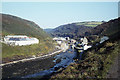
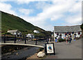
7
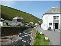
The River Valency, Boscastle
The visitor centre is on the right, and in the distance the new bridge over the river. The tall block to the left of the bridge is Harbour Terrace.
Image: © Humphrey Bolton
Taken: 7 May 2009
0.01 miles
8
After the flood at Boscastle
Compare this image with Image] to see that the reconstruction is a brave attempt but a long way from capturing the quaint dilapidation of the original. In fairness you can't look at this as a mere repair of the Pisky House/Harbour Lights. The pigsty origin of the previous building meant it was ill-equipped to withstand the flood and it didn't just deteriorate - it disintegrated completely. What stands there today is a ground-up attempt at a facsimile, although it does incorporate the original stone lintels.
Image: © Roger Lombard
Taken: 21 May 2010
0.01 miles
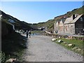
9
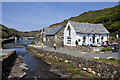
Lower Bridge at Boscastle
There are two publicly accessible bridges at Boscastle; the lower bridge being for pedestrian traffic and the upper one carrying the B3263 through the village.
This photograph shows the lower bridge before the catastrophic floods of Monday, 16 August 2004.
For more information, click here:-
https://en.wikipedia.org/wiki/Boscastle_flood_of_2004 (Wikipedia) and
https://sites.google.com/site/ukfloods/flooding-case-studies/boscastle-flood-2004 (sites.google.com).
The bridge was severely damaged and, although temporarily repaired, was demolished in 2008 and replaced by a wider more modern structure positioned some 3metres downstream.
The building on the left is Boscastle YHA. Hidden from view by the YHA building was Image, which was completely destroyed by the same flood event.
See also this 2017 photograph taken from a similar viewpoint:- Image
***
See also these photographs by,
Chris Downer:- Image and
Rowena Ford:- Image
Image: © Alan Walker
Taken: Unknown
0.01 miles
10
Footbridge and the Museum of Witchcraft, Boscastle
The footbridge carries the South West Coast path over the River Valency.
Image: © habiloid
Taken: 1 Aug 2013
0.02 miles