Lower Bridge at Boscastle
Introduction
The photograph on this page of Lower Bridge at Boscastle by Alan Walker as part of the Geograph project.
The Geograph project started in 2005 with the aim of publishing, organising and preserving representative images for every square kilometre of Great Britain, Ireland and the Isle of Man.

There are currently over 7.5m images from over 14,400 individuals and you can help contribute to the project by visiting https://www.geograph.org.uk
Lower Bridge at Boscastle
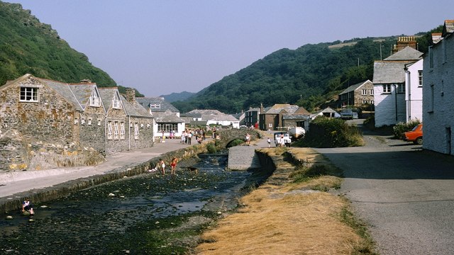
Image: © Alan Walker Taken: Unknown
There are two publicly accessible bridges at Boscastle; the lower bridge being for pedestrian traffic and the upper one carrying the B3263 through the village. This photograph shows the lower bridge before the catastrophic floods of Monday, 16 August 2004. For more information, click here:- https://en.wikipedia.org/wiki/Boscastle_flood_of_2004 (Wikipedia) and https://sites.google.com/site/ukfloods/flooding-case-studies/boscastle-flood-2004 (sites.google.com). The bridge was severely damaged and, although temporarily repaired, was demolished in 2008 and replaced by a wider more modern structure positioned some 3metres downstream. The building on the left is Boscastle YHA. Hidden from view by the YHA building was Image, which was completely destroyed by the same flood event. See also this 2017 photograph taken from a similar viewpoint:- Image *** See also these photographs by, Chris Downer:- Image and Rowena Ford:- Image
Images are licensed for reuse under creativecommons.org/licenses/by-sa/2.0
Image Location
Latitude
50.690425
Longitude
-4.695168