IMAGES TAKEN NEAR TO
Carpenter Court, BODMIN, PL31 2ET
Introduction
This page details the photographs taken nearby to Carpenter Court, PL31 2ET by members of the Geograph project.
The Geograph project started in 2005 with the aim of publishing, organising and preserving representative images for every square kilometre of Great Britain, Ireland and the Isle of Man.

There are currently over 7.5m images from over14,400 individuals and you can help contribute to the project by visiting https://www.geograph.org.uk
Image Map (Loading...)


Getting Data...Please wait
Leaflet Map data © OpenStreetMap
Images are licensed for reuse under creativecommons.org/licenses/by-sa/2.0
Notes
- Clicking on the map will re-center to the selected point.
- The higher the marker number, the further away the image location is from the centre of the postcode.
Image Listing (37 Images Found)
Images are licensed for reuse under creativecommons.org/licenses/by-sa/2.0
Image
Details
Distance
1
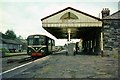
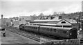
Bodmin North Station, 1964
This was the terminus of the Bodmin and Wadebridge Railway, opened in 1834, and therefore preceding the main line railways that eventually reached Wadebridge (LSWR, late Southern Railway) and Bodmin Road (GWR) with a separate branch to the town. As a result it remained a backwater with a low level of passenger numbers.
It was one of the branches selected in the 1960s for operation with 4-wheel railbuses of the type seen here, but these were short lived, the line succumbing to the Beeching cuts in January 1967. Even the subsequent Bodmin and Wenford Railway, a heritage line, uses the former GWR station.
The station has disappeared without trace. This view https://www.geograph.org.uk/photo/3376293 is taken from almost the exact spot as mine. The house with the cream gable can be glimpsed under the station canopy.
Image: © Alan Murray-Rust
Taken: Unknown
0.15 miles
3
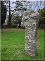
Old Wayside Cross
Berry Tower Cross, a moved Wayside Cross with an old head and shaft. Set beside the ruined church tower in Berry Hill cemetery in Bodmin parish. Grade II* Listed https://historicengland.org.uk/listing/the-list/list-entry/1195254. See also https://www.flickr.com/photos/bridgemarkertim/14206338102/.
Milestone Society National ID: CWNC_BOD03
Image: © L Nott
Taken: 19 Oct 2020
0.15 miles
4
Site of Bodmin North Station
See Image] for a 50 year comparison.
Image: © Ashley Dace
Taken: 18 Mar 2013
0.16 miles
5
Bodmin North Station
View NW: buffer-stops right, Wadebridge left; ex-LSW terminus of branch from Wadebridge, closed completely 30/1/67. Local train for Wadebridge and Padstow in platform, headed by an LMS-type Ivatt Class 2 2-6-2T.
Image: © Ben Brooksbank
Taken: 20 Apr 1964
0.16 miles
6
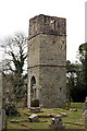
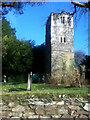
Berry Tower
Berry Tower was originally constructed between 1501 and 1511 and formed part of a large chapel which has since disappeared. The cemetery which now surrounds the tower was established in the 19th century.
Image: © Tony Atkin
Taken: 5 Apr 2008
0.16 miles
7
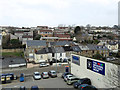
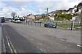
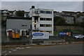
End of Sainsbury's car park and Brownlow Place, Bodmin
Housing on the hillside is reached from Berrycombe Road, Wallace Road and Harmer Close.
Image: © Robin Stott
Taken: 16 Mar 2015
0.16 miles
8
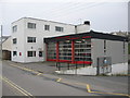
Bodmin Fire Station
A view looking south across Berrycombe Road towards Bodmin Fire Station. The building has received a new set of doors since the 1991 geograph by Kevin Hale.
Image: © Phil Williams
Taken: 25 Mar 2007
0.17 miles
9
Bodmin fire station
Seen from the Sainsbury's car park built on the site of the former Bodmin North station.
Image: © Christopher Hilton
Taken: 27 Oct 2016
0.17 miles
10
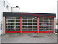
Bodmin Fire Station
A view looking to the southwest towards Bodmin Fire station.
Image: © Phil Williams
Taken: 25 Mar 2007
0.17 miles