IMAGES TAKEN NEAR TO
Flamank Park, BODMIN, PL31 1LY
Introduction
This page details the photographs taken nearby to Flamank Park, PL31 1LY by members of the Geograph project.
The Geograph project started in 2005 with the aim of publishing, organising and preserving representative images for every square kilometre of Great Britain, Ireland and the Isle of Man.

There are currently over 7.5m images from over14,400 individuals and you can help contribute to the project by visiting https://www.geograph.org.uk
Image Map
Images are licensed for reuse under creativecommons.org/licenses/by-sa/2.0
Notes
- Clicking on the map will re-center to the selected point.
- The higher the marker number, the further away the image location is from the centre of the postcode.
Image Listing (46 Images Found)
Images are licensed for reuse under creativecommons.org/licenses/by-sa/2.0
Image
Details
Distance
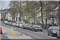
1
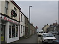
Higher Bore Street
A view looking west along Higher Bore Street towards Town End.
Image: © Phil Williams
Taken: 25 Mar 2007
0.13 miles
2
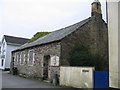
St Leonards Chapel
A view looking to the southeast towards the now disused. St. Leonards Chapel on Higher Bore Street. This is still shown as a place of worship on the 1:50,000 OS map, but not on the 1:25,000.
Image: © Phil Williams
Taken: 25 Mar 2007
0.15 miles
3
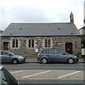
The state of religion in Bodmin, 5
A former chapel has been converted to a private house.
Image: © Robin Stott
Taken: 16 Mar 2015
0.15 miles
4
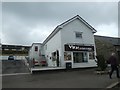
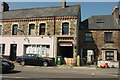
Indian takeaway, Higher Bore Street, Bodmin
Image: © David Smith
Taken: 7 Sep 2020
0.16 miles
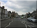
5
Bodmin : Higher Bore Street
Higher Bore Street in the centre of Bodmin.
Image: © Lewis Clarke
Taken: 23 Feb 2014
0.16 miles
7
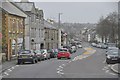
Bodmin : Higher Bore Street
Higher Bore Street in the centre of Bodmin in Cornwall.
Image: © Lewis Clarke
Taken: 23 Feb 2014
0.17 miles
8
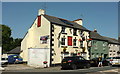
The Garland Ox, Bodmin
On Higher Bore Street, the A389. The figure by the car is wearing a pub top.
Image: © Derek Harper
Taken: 16 Aug 2016
0.17 miles
9
Cafe, Bodmin
The Talk Of The Town occupies the premises of a pub, which is how maps show it, but I've not yet identified the name of the pub. Seen across St Leonards where it changes to Higher Bore Street.
Image: © Derek Harper
Taken: 16 Aug 2016
0.17 miles
10
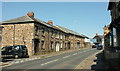
St Leonard's Terrace, Bodmin
Facing the road named St Leonard's, the A389. Neither has the inverted comma on the maps, but it seems to be used a fair amount elsewhere.
Image: © Derek Harper
Taken: 16 Aug 2016
0.17 miles