IMAGES TAKEN NEAR TO
Priory Road, BODMIN, PL31 1HG
Introduction
This page details the photographs taken nearby to Priory Road, PL31 1HG by members of the Geograph project.
The Geograph project started in 2005 with the aim of publishing, organising and preserving representative images for every square kilometre of Great Britain, Ireland and the Isle of Man.

There are currently over 7.5m images from over14,400 individuals and you can help contribute to the project by visiting https://www.geograph.org.uk
Image Map
Images are licensed for reuse under creativecommons.org/licenses/by-sa/2.0
Notes
- Clicking on the map will re-center to the selected point.
- The higher the marker number, the further away the image location is from the centre of the postcode.
Image Listing (14 Images Found)
Images are licensed for reuse under creativecommons.org/licenses/by-sa/2.0
Image
Details
Distance
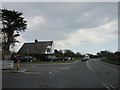
1
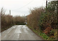
Canyke Road
The road. seen looking in the opposite direction from Image], approaches its junction with the A38.
Image: © Derek Harper
Taken: 7 Feb 2020
0.01 miles
2
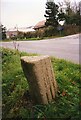
Old Milestone by the A38 near Castle Canyke Farm
Carved stone post by the A38, in parish of BODMIN (NORTH CORNWALL District), Castle Canyke Farm, South of junction, Chy Praze, 20m from toll house on brow of hill, by the road, on East side of road. BL triangle, erected by the Bodmin turnpike trust in the 19th century.
Inscription reads:-
: L / 11½ : : B / 1 :
Grade II Listed. List Entry Number: 1393078
https://historicengland.org.uk/listing/the-list/list-entry/1393078
Milestone Society National ID: CW_BMLK01.
Image: © Ian Thompson
Taken: 1 Oct 1995
0.04 miles
3
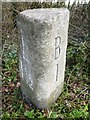
Old Milestone by the A38 east of Bodmin
Carved stone post by the A38, in parish of BODMIN (NORTH CORNWALL District), Castle Canyke Farm, South of junction, Chy-Praze, 20m from toll house on brow of hill, by the road, on East side of road. 'BL' triangle, erected by the Bodmin turnpike trust in the 19th century.
Inscription reads:-
: L / 11½ : : B / 1 :
Grade II listed.
List Entry Number: 1393078 https://historicengland.org.uk/listing/the-list/list-entry/1393078
Milestone Society National ID: CW_BMLK01.
Image: © Rosy Hanns
Taken: 22 Mar 2019
0.04 miles
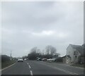
4
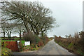
Canyke Road
Passing The Leans campsite on the left, with wintry beeches by the lane.
Image: © Derek Harper
Taken: 7 Feb 2020
0.06 miles
7
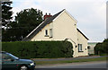
Tollhouse by the A38 at Fourways, Bodmin
Tollhouse at the junction of Priory Road with Cooksland Road (A38), at Fourways in the parish of Bodmin (North Cornwall District).
Cornwall & Scilly HER.
HER Number: 176779 https://www.heritagegateway.org.uk/Gateway/Results_Single.aspx?uid=MCO52588&resourceID=1020
Surveyed
Milestone Society National ID: CW.BOD02
Image: © Alan Rosevear
Taken: 19 Sep 2008
0.11 miles
8
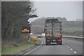
North Cornwall : The A30 Road
Taken to show that the signs are all working correctly.
Image: © Lewis Clarke
Taken: 23 Feb 2012
0.14 miles
9
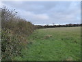
Earth bank at Castle Canyke
The bank around this massive Iron Age defensive settlement is incorporated into the field boundary hedge.
Image: © Rod Allday
Taken: 7 Nov 2015
0.15 miles
10
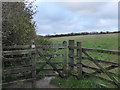
Gateway at Castle Canyke
Castle Canyke is a massive Iron Age defensive settlement approximately 400m in diameter, with a bank & ditch around it (most visible on the SW side). Access under the Countryside Stewardship Scheme is through this kissing gate on the NW side of the settlement.
Image: © Rod Allday
Taken: 7 Nov 2015
0.18 miles