IMAGES TAKEN NEAR TO
Carminnow Road Industrial Estate, BODMIN, PL31 1EP
Introduction
This page details the photographs taken nearby to Carminnow Road Industrial Estate, PL31 1EP by members of the Geograph project.
The Geograph project started in 2005 with the aim of publishing, organising and preserving representative images for every square kilometre of Great Britain, Ireland and the Isle of Man.

There are currently over 7.5m images from over14,400 individuals and you can help contribute to the project by visiting https://www.geograph.org.uk
Image Map
Images are licensed for reuse under creativecommons.org/licenses/by-sa/2.0
Notes
- Clicking on the map will re-center to the selected point.
- The higher the marker number, the further away the image location is from the centre of the postcode.
Image Listing (10 Images Found)
Images are licensed for reuse under creativecommons.org/licenses/by-sa/2.0
Image
Details
Distance
1
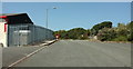
Carminow Road Industrial Estate
Ahead are the gates shown in Image
Image: © Derek Harper
Taken: 16 Aug 2016
0.05 miles
2
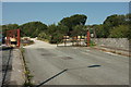
Carminow Road Industrial Estate
A road ending in tracks - actually very close to Castle Canyke Road, just behind the bushes.
Image: © Derek Harper
Taken: 16 Aug 2016
0.06 miles
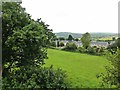
3
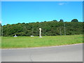
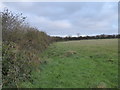
Castle Canyke
A view across the northwest quadrant of Castle Canyke, Bodmin. the bank and ditch earthwork can be seen along the hedge bordering the minor road. Beacon Hill with the Gilbert monument can be seen on the horizon.
Image: © Phil Williams
Taken: 8 Oct 2005
0.12 miles
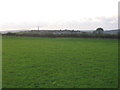
4
Farmland Near Bodmin
Rolling land and plenty rain in a mild climate produces good grazing land which, in turn, produces the famous West Country dairy products. Viewed from a train on the steam heritage line just outside Bodmin.
Image: © Mary and Angus Hogg
Taken: 28 Jun 2016
0.14 miles
5

A30 : Carminow Cross Roundabout
A roundabout providing access into Bodmin, onto the A30 and the A38.
Image: © Lewis Clarke
Taken: 17 Jul 2015
0.18 miles
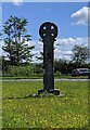
6
Carminow Cross
A Cornish Cross stands in the centre of this large roundabout. The exit to Bodmin is upper right.
Image: © William Bartlett
Taken: 8 Aug 2007
0.19 miles
7
Old Wayside Cross on Carminhow Road in Bodmin
Carminow Cross, a wayside cross with an old head and shaft. Set on grass in the centre of Carminow Road roundabout at the junction of the A30 and the A38 in Bodmin parish. Langdon NC No. 07. Grade II Listed https://historicengland.org.uk/listing/the-list/list-entry/1298242. See also http://www.flickr.com/photos/ocifant/1656603166.
Milestone Society National ID: CWNC_BOD07
Image: © L Nott
Taken: 5 Jun 2021
0.21 miles
8
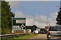
Cornwall : A30 Sliproad
A sliproad off of the A30 and down onto Carminow Cross Roundabout.
Image: © Lewis Clarke
Taken: 17 Jul 2015
0.22 miles
9
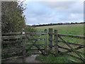
Gateway at Castle Canyke
Castle Canyke is a massive Iron Age defensive settlement approximately 400m in diameter, with a bank & ditch around it (most visible on the SW side). Access under the Countryside Stewardship Scheme is through this kissing gate on the NW side of the settlement.
Image: © Rod Allday
Taken: 7 Nov 2015
0.22 miles
10
Earth bank at Castle Canyke
The bank around this massive Iron Age defensive settlement is incorporated into the field boundary hedge.
Image: © Rod Allday
Taken: 7 Nov 2015
0.24 miles