IMAGES TAKEN NEAR TO
Keybridge, BODMIN, PL30 4QL
Introduction
This page details the photographs taken nearby to PL30 4QL by members of the Geograph project.
The Geograph project started in 2005 with the aim of publishing, organising and preserving representative images for every square kilometre of Great Britain, Ireland and the Isle of Man.

There are currently over 7.5m images from over14,400 individuals and you can help contribute to the project by visiting https://www.geograph.org.uk
Image Map
Images are licensed for reuse under creativecommons.org/licenses/by-sa/2.0
Notes
- Clicking on the map will re-center to the selected point.
- The higher the marker number, the further away the image location is from the centre of the postcode.
Image Listing (14 Images Found)
Images are licensed for reuse under creativecommons.org/licenses/by-sa/2.0
Image
Details
Distance
1
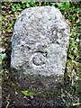
Old Boundary Marker
County Bridge Marker on the north side of a minor road east of Keybridge village and 100 metres west of Key Bridge
on the De Lank River. St Breward parish. Inscribed C. The stone marks the extent of roadway adjoining the bridge that the County was obliged to maintain.
Milestone Society National ID: CW_STBD01br
Image: © R Hanns
Taken: 20 Oct 2019
0.02 miles
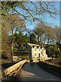
2
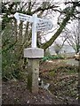
Old Guide Stone at Keybridge, St Breward parish
Guide Stone by the UC road, in parish of St Breward (North Cornwall District), Keybridge, by the road.
Grade II listed.
List Entry Number: 1327912 https://historicengland.org.uk/listing/the-list/list-entry/1327912
Surveyed
Milestone Society National ID: CW_XSTBR2
Image: © Milestone Society
Taken: Unknown
0.05 miles
3
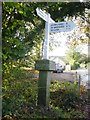
Old Guide Stone by the Camelford Trail in Keybridge
Guide Stone by the UC road, in parish of St Breward (North Cornwall District), Keybridge, by the road.
Inscription reads:-
: BODMIN : : CAMEL / FORD : ST TUDY :
Grade II listed.
List Entry Number: 1327912 https://historicengland.org.uk/listing/the-list/list-entry/1327912
Surveyed
Milestone Society National ID: CW_XSTBR2
Image: © Rosy Hanns
Taken: 10 Nov 2019
0.05 miles
4
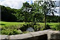
North Cornwall : River Camel
Crossing the River Camel on one of the country lanes in North Cornwall.
Image: © Lewis Clarke
Taken: 1 Jul 2011
0.06 miles
5
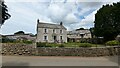
Farmhouse at Keybridge
https://historicengland.org.uk/listing/the-list/list-entry/1158640?section=official-list-entry
Image: © Sandy Gerrard
Taken: 20 Jun 2024
0.06 miles
6
Bridge over De Lank River, Keybridge
With Tremasden beyond. The bridge is listed https://www.historicengland.org.uk/listing/the-list/list-entry/1146446 and has a sundial set into the cutwater on the right, which I failed to notice.
Image: © Derek Harper
Taken: 25 Jan 2017
0.07 miles
7
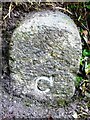
Old Boundary Marker
County Bridge Marker on the west side of a minor road 100 metres south of Key Bridge on the De Lank River. Blisland parish. Inscribed C. The stone marks the extent of roadway adjoining the bridge that the County was obliged to maintain.
Milestone Society National ID: CW_BLIS01br
Image: © R Hanns
Taken: 20 Oct 2019
0.07 miles
8
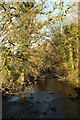
De Lank River from Keybridge
Looking upstream (left) from the bridge shown in Image
Image: © Derek Harper
Taken: 25 Jan 2017
0.09 miles
9
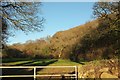
Field, Keybridge
Looking left from where Image was taken. The De lank River runs along the right side of the field. The wood climbing the hillside is unnamed on maps.
Image: © Derek Harper
Taken: 25 Jan 2017
0.09 miles
10
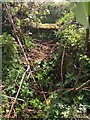
Stone Stile SX0973b
On the narrow lane that leads downhill from Tregenna (north west of Blisland) to Tregaddick.
Badly maintained, overgrown stile, which, at a guess, comprises three/four steps on both sides topped with another step on its side.
This stile gives access into a field and is part of FP No. 593/1/1 (Bronze). However, at its far end, it goes through the grounds of a property called ‘Tremasden’ at Keybridge, where the path has become overgrown with bushes etc. and ends at the de Lank River, with no official access to the nearby lane. It has therefore become unused.
Image: © Anne Green
Taken: 11 May 2021
0.15 miles