IMAGES TAKEN NEAR TO
Churchtown Mews, BODMIN, PL30 4JA
Introduction
This page details the photographs taken nearby to Churchtown Mews, PL30 4JA by members of the Geograph project.
The Geograph project started in 2005 with the aim of publishing, organising and preserving representative images for every square kilometre of Great Britain, Ireland and the Isle of Man.

There are currently over 7.5m images from over14,400 individuals and you can help contribute to the project by visiting https://www.geograph.org.uk
Image Map
Images are licensed for reuse under creativecommons.org/licenses/by-sa/2.0
Notes
- Clicking on the map will re-center to the selected point.
- The higher the marker number, the further away the image location is from the centre of the postcode.
Image Listing (85 Images Found)
Images are licensed for reuse under creativecommons.org/licenses/by-sa/2.0
Image
Details
Distance
1
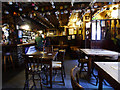
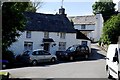
Blisland Inn
Not a day for sitting outside enjoying a cider or too. In fact you want the log fire roaring up the chimney as its cold and raw.
Image: © roger geach
Taken: 14 Dec 2009
0.02 miles
3
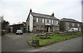
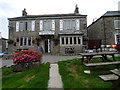
The Coach House and The Blisland Inn, Blisland
Grade II Listed Coach House has an 1869 datestone and has been converted to holiday cottages. The granite trough has been re-sited. The mid 19th century Blisland Inn is a former winner of the CAMRA National Pub of the Year. Documents of 1816 describes a meeting at the public house at Blisland Church Town, so it would seem reasonable to suppose this building was then the inn. The Ordnance Survey Map of 1880 shows the building adjacent to Church Town operating as the Blisland Inn. The public house which had changed its name to Ye Royal Oak Inn was described in Kelly’s Directory of 1910 as ‘good accommodation for cyclists and anglers’. Churchtown Cottage a Grade II Listed building is partly in view on the right.
Image: © Jo and Steve Turner
Taken: 21 Jun 2019
0.03 miles
4
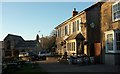
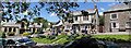
Blisland Inn
On the north side of the village green which is off to the left, and passes by NCN3. On the left is The Coach House (1869) https://www.historicengland.org.uk/listing/the-list/list-entry/1328296 .
Image: © Derek Harper
Taken: 25 Jan 2017
0.03 miles
6

The Blisland Inn
This public house is situated on the western edge of the green at the heart of the village of Blisland.
Image: © Tony Atkin
Taken: 23 Jul 2010
0.03 miles
7
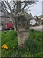
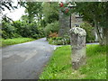
Old Central Cross beside the green in Blisland
Blisland Village Cross, the head and neck of an old wayside cross on a grass triangle beside the green where Tregenna Road joins the village main street in Blisland parish. Grade II Listed https://historicengland.org.uk/listing/the-list/list-entry/1142366. See also http://www.flickr.com/photos/ocifant/2880305692.
Milestone Society National ID: CWNC_BLI08
Image: © L Nott
Taken: 5 Feb 2022
0.03 miles
9
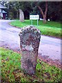
Old Cross, Blisland
The Millennium Stone in the background.
Image: © Chris Andrews
Taken: 25 Sep 2017
0.03 miles
10
Ancient cross beside the road at Blisland
This cross is situated at the staggered junction of four roads at the western end of the village green in Blisland village on the western fringes of Bodmin Moor. It has always been recorded at this location since its first depiction by the Ordnance Survey in 1881. This junction marks the crossing point of routes linking the towns and settlements of the north west coastal strip of Cornwall and western Bodmin Moor with one of the main early east-west routes across Cornwall, now the A30, and its early link with the crossing point of the River Camel at Wadebridge. On a local level, this cross is one of an unusually large number of medieval wayside crosses within this parish which marked the main routes to the church, situated 175m south east of this monument. A Scheduled Monument https://www.historicengland.org.uk/listing/the-list/list-entry/1010842.
Image: © Rod Allday
Taken: 1 Aug 2017
0.03 miles