IMAGES TAKEN NEAR TO
Ashdown Close, ST. AUSTELL, PL26 7EU
Introduction
This page details the photographs taken nearby to Ashdown Close, PL26 7EU by members of the Geograph project.
The Geograph project started in 2005 with the aim of publishing, organising and preserving representative images for every square kilometre of Great Britain, Ireland and the Isle of Man.

There are currently over 7.5m images from over14,400 individuals and you can help contribute to the project by visiting https://www.geograph.org.uk
Image Map (Loading...)


Getting Data...Please wait
Leaflet Map data © OpenStreetMap
Images are licensed for reuse under creativecommons.org/licenses/by-sa/2.0
Notes
- Clicking on the map will re-center to the selected point.
- The higher the marker number, the further away the image location is from the centre of the postcode.
Image Listing (10 Images Found)
Images are licensed for reuse under creativecommons.org/licenses/by-sa/2.0
Image
Details
Distance
4
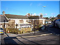
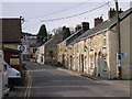
The Hewas Inn in Sticker
Sticker is now a quiet backwater since it was bypassed by the Truro-St Austell road in the late C20th.
Image: © Rod Allday
Taken: 22 Jan 2010
0.16 miles
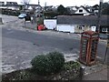
5
The Village of Sticker
Sticker village grew up with the mining industry in the 19th century. When that industry declined in the latter half of the century, people were able to find work in the local china clay industry. Although the clay industry is still here, it became increasingly mechanised through the latter half of the 20th century and ceased to be a major employer.
Image: © Tony Atkin
Taken: 28 Jan 2006
0.17 miles
6
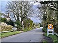
Sticker Village
Road signs at the village entrance.
Image: © Jay Pea
Taken: 26 Dec 2021
0.17 miles
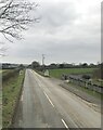
8

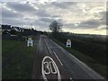
A 390 Trunk Road
Very little traffic on this normally busy road, on Boxing Day 2021.
Image: © Jay Pea
Taken: 26 Dec 2021
0.19 miles
9
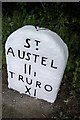
Old Milestone by the A390 in Sticker
Carved stone post by the A390, in parish of ST MEWAN (RESTORMEL District), Sticker; opposite "Mors Hus", by the road, on North side of road. St Austell Roman stone, erected by the St Austell & Lostwithiel turnpike trust in the 18th century.
Inscription reads:-
ST
AUSTEL
IIi
TRURO
XI
Carved benchmark and rivet on top.
Grade II Listed. List Entry Number:1144015
https://historicengland.org.uk/listing/the-list/list-entry/1144015
Milestone Society National ID: CW_TOSA11.
Image: © Ian Thompson
Taken: 1 Jun 1996
0.25 miles
10

Old Milestone in Sticker
Carved stone post on Rose Hill, in parish of ST MEWAN (RESTORMEL District), Sticker; opposite "Mors Hus", on North side of road. St Austell Roman stone, erected by the St Austell & Lostwithiel turnpike trust in the 18th century.
Inscription reads:-
ST
AUSTEL
IIi
TRURO
XI
Carved benchmark and rivet on top.
Grade II Listed. List Entry Number:1144015
https://historicengland.org.uk/listing/the-list/list-entry/1144015
Milestone Society National ID: CW_TOSA11
Image: © P Barnett
Taken: 10 Jul 2024
0.25 miles