IMAGES TAKEN NEAR TO
Tregoney Hill, ST. AUSTELL, PL26 6RQ
Introduction
This page details the photographs taken nearby to Tregoney Hill, PL26 6RQ by members of the Geograph project.
The Geograph project started in 2005 with the aim of publishing, organising and preserving representative images for every square kilometre of Great Britain, Ireland and the Isle of Man.

There are currently over 7.5m images from over14,400 individuals and you can help contribute to the project by visiting https://www.geograph.org.uk
Image Map (Loading...)


Getting Data...Please wait
Leaflet Map data © OpenStreetMap
Images are licensed for reuse under creativecommons.org/licenses/by-sa/2.0
Notes
- Clicking on the map will re-center to the selected point.
- The higher the marker number, the further away the image location is from the centre of the postcode.
Image Listing (7 Images Found)
Images are licensed for reuse under creativecommons.org/licenses/by-sa/2.0
Image
Details
Distance
1
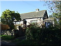
House on the outskirts of Mevagissey
On Tregoney Hill.
Image: © JThomas
Taken: 5 Nov 2014
0.07 miles
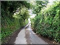
2
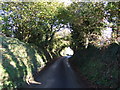
Descent into Mevagissey
Heading east on Tregoney Hill, a narrow lane with high banks.
Image: © JThomas
Taken: 5 Nov 2014
0.09 miles
3
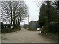
Farm track and footpath
On a less foggy afternoon the walk down to the coast at Mevagissey would be a delight.
Image: © Jonathan Billinger
Taken: 17 Mar 2010
0.11 miles
4
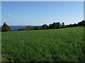
Farmland off Tregoney Hill
With distant view of the sea.
Image: © JThomas
Taken: 5 Nov 2014
0.12 miles
5
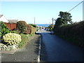
Tregoney Hill, Mevagissey
Heading east into the port.
Image: © JThomas
Taken: 5 Nov 2014
0.18 miles
7
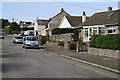
Edge of Town
Mevagissey has its famous old town centre with narrow streets clustered round the harbour, but here, 50 metres above that on the edge of the town are suburban streets and closes which could be anywhere at all.
Image: © Tony Atkin
Taken: 7 Oct 2006
0.22 miles