IMAGES TAKEN NEAR TO
Gover Road, ST. AUSTELL, PL25 5NG
Introduction
This page details the photographs taken nearby to Gover Road, PL25 5NG by members of the Geograph project.
The Geograph project started in 2005 with the aim of publishing, organising and preserving representative images for every square kilometre of Great Britain, Ireland and the Isle of Man.

There are currently over 7.5m images from over14,400 individuals and you can help contribute to the project by visiting https://www.geograph.org.uk
Image Map
Images are licensed for reuse under creativecommons.org/licenses/by-sa/2.0
Notes
- Clicking on the map will re-center to the selected point.
- The higher the marker number, the further away the image location is from the centre of the postcode.
Image Listing (7 Images Found)
Images are licensed for reuse under creativecommons.org/licenses/by-sa/2.0
Image
Details
Distance
1
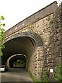
Railway bridges, Trenance Road
A little west of Trenance viaduct, these fine arches spanning Trenance Road at an angle carry the main line from nearby St Austell to Penzance (or at least, the nearer bridge does).
Image: © Derek Harper
Taken: 18 May 2009
0.11 miles
2
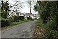
The western end of Gover Road
Further away from the town centre this valley-bottom road starts to look more like a country lane.
Image: © Tony Atkin
Taken: 19 Nov 2005
0.12 miles
3
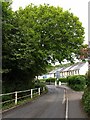
Gover Road, St Austell
Another view along Image, looking up the valley of the Gover Stream, which runs beside the road.
Image: © Derek Harper
Taken: 18 May 2009
0.14 miles
4
Trenance Road
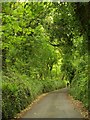
A very green lane climbing above Image up the northern slopes of the Gover Stream valley.
Image: © Derek Harper
Taken: 18 May 2009
0.15 miles
5
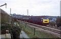
Passing the old clay driers
Passing a disused clay drier is the morning Bristol to Penzance service having just left St Austell station a few minutes before. Many of these smaller clay driers shut in the 1960s as larger driers took over drying clay from a number of the clay pits.
Image: © roger geach
Taken: 22 Oct 1976
0.16 miles
6
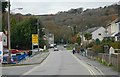
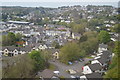
Gover Road, St Austell
in the St Austell suburbs to the west of the town centre. Housing covers the valley floor and the south facing slopes but wisely the steep north facing slopes have been left to the trees.
Image: © Tony Atkin
Taken: 19 Nov 2005
0.21 miles