IMAGES TAKEN NEAR TO
PL25 5GJ
Introduction
This page details the photographs taken nearby to PL25 5GJ by members of the Geograph project.
The Geograph project started in 2005 with the aim of publishing, organising and preserving representative images for every square kilometre of Great Britain, Ireland and the Isle of Man.

There are currently over 7.5m images from over14,400 individuals and you can help contribute to the project by visiting https://www.geograph.org.uk
Image Map
Images are licensed for reuse under creativecommons.org/licenses/by-sa/2.0
Notes
- Clicking on the map will re-center to the selected point.
- The higher the marker number, the further away the image location is from the centre of the postcode.
Image Listing (14 Images Found)
Images are licensed for reuse under creativecommons.org/licenses/by-sa/2.0
Image
Details
Distance
1
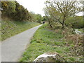
Wheal Martyn Trail
Part of the extensive Wheal Martyn trail, going towards St. Austell.
Image: © Jay Pea
Taken: 7 May 2021
0.04 miles
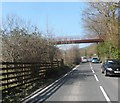
3
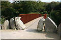
Cycle Trail Bridge
This bridge takes one of the Clay Trails cycleways over the road along the St Austell River valley.
Image: © Tony Atkin
Taken: 21 Sep 2008
0.06 miles
4
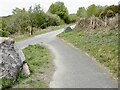
Track junction
The Wheal Martyn trail junction, to the Eden project ahead, St Austell behind and back to Wheal Martyn to the left.
Image: © Jay Pea
Taken: 7 May 2021
0.09 miles
5
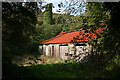
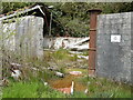
Disused China Clay Works
A dilapidated tin-roofed shed and a chimney stack covered in ivy are probably only part of the old works hidden in the vegetation here. Clay country is littered with remains like this.
Image: © Tony Atkin
Taken: 21 Sep 2008
0.14 miles
6
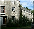
The Mill House, Bojea
The building on the left is a former corn mill, about 200 years old. Some of the original mill machinery still exists inside, and I was told there are also parts of the water wheel. See the owners' website for information on bed and breakfast http://www.chycor.co.uk/bnb/staustell-the-mill-house/index.htm - we enjoyed staying here.
Image: © Rich Tea
Taken: 4 Aug 2006
0.16 miles
7
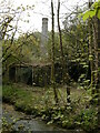
Disused Clay works
Another view of the disused Clay works.
Image: © Jay Pea
Taken: 7 May 2021
0.19 miles
8
Disused Clay works
The same works as submitted by T Atkin, many years ago, much more overgrown and the building falling down.
Image: © Jay Pea
Taken: 7 May 2021
0.20 miles
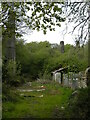
9
Disused Clay works
Of note is the raised railway and derelict wheels on the back wall
Image: © Jay Pea
Taken: 7 May 2021
0.20 miles
10
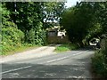
The road to St Austell, Bojea
Bojea Farm is beyond the trees across the road, and the sign for Trethowel is down the road near the cars. The road is the B3274.
Image: © Rich Tea
Taken: 4 Aug 2006
0.21 miles