IMAGES TAKEN NEAR TO
Sparnon Close, ST. AUSTELL, PL25 5AR
Introduction
This page details the photographs taken nearby to Sparnon Close, PL25 5AR by members of the Geograph project.
The Geograph project started in 2005 with the aim of publishing, organising and preserving representative images for every square kilometre of Great Britain, Ireland and the Isle of Man.

There are currently over 7.5m images from over14,400 individuals and you can help contribute to the project by visiting https://www.geograph.org.uk
Image Map
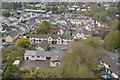
Images are licensed for reuse under creativecommons.org/licenses/by-sa/2.0
Notes
- Clicking on the map will re-center to the selected point.
- The higher the marker number, the further away the image location is from the centre of the postcode.
Image Listing (23 Images Found)
Images are licensed for reuse under creativecommons.org/licenses/by-sa/2.0
Image
Details
Distance
1
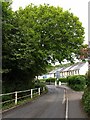
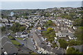
Gover Road, St Austell
Another view along Image, looking up the valley of the Gover Stream, which runs beside the road.
Image: © Derek Harper
Taken: 18 May 2009
0.07 miles
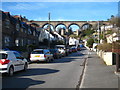
4
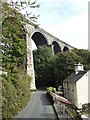
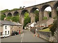
St Austell viaduct
The Penzance line crosses the Trenance valley to the west of St Austell town centre. It is 115 feet high, 720 feet long, and has 10 piers.
The original viaducts built by I K Brunel on this line were wooden viaducts built on top of stone piers for speed and cheapness. On rebuilding, most of the new all-stone viaducts were built on a slightly different alignment to allow trains to continue running, the line being switched to the new alignment on completion of the new viaduct. The timber works of the old viaducts were then removed, leaving the stone piers still standing. Three of these old piers are visible in the photo (the third almost completely hidden by greenery).
The cottages don't really lean in Cornwall!
Image: © Jonathan Billinger
Taken: 3 Oct 2007
0.12 miles
6
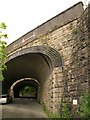
Railway bridges, Trenance Road
A little west of Trenance viaduct, these fine arches spanning Trenance Road at an angle carry the main line from nearby St Austell to Penzance (or at least, the nearer bridge does).
Image: © Derek Harper
Taken: 18 May 2009
0.14 miles
7
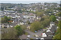
Grove Road St Austell
Part of the housing development in the Gover Valley, which is spanned by the railway viaduct carrying the London - Penzance main line.
Image: © Rod Allday
Taken: 8 Apr 2010
0.15 miles
8
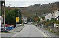
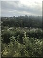
Gover Road, St Austell
in the St Austell suburbs to the west of the town centre. Housing covers the valley floor and the south facing slopes but wisely the steep north facing slopes have been left to the trees.
Image: © Tony Atkin
Taken: 19 Nov 2005
0.15 miles
10
Trenance Road
The junction with Grover Road (left). Dominating the scene is the Trenance Viaduct, carrying the main railway line to Penzance, and with the piers of an earlier 1850s viaduct alongside. The later viaduct dates from 1899.
Image: © Derek Harper
Taken: 18 May 2009
0.17 miles