IMAGES TAKEN NEAR TO
Boldventure Close, ST. AUSTELL, PL25 3DY
Introduction
This page details the photographs taken nearby to Boldventure Close, PL25 3DY by members of the Geograph project.
The Geograph project started in 2005 with the aim of publishing, organising and preserving representative images for every square kilometre of Great Britain, Ireland and the Isle of Man.

There are currently over 7.5m images from over14,400 individuals and you can help contribute to the project by visiting https://www.geograph.org.uk
Image Map
Images are licensed for reuse under creativecommons.org/licenses/by-sa/2.0
Notes
- Clicking on the map will re-center to the selected point.
- The higher the marker number, the further away the image location is from the centre of the postcode.
Image Listing (11 Images Found)
Images are licensed for reuse under creativecommons.org/licenses/by-sa/2.0
Image
Details
Distance
2
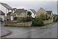
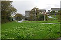
Retallick Meadows
Modern housing on the eastern edge of St Austell just off Trenowah Road.
Image: © Tony Atkin
Taken: 12 Nov 2005
0.15 miles
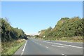
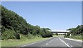
3

Bridge carrying track over A391 from Boscoppa
Beyond the bridge is an advance sign for an escape lane on the downhill stretch of the road. The bridge carries a public footpath.
Image: © David Smith
Taken: 2 Jun 2011
0.16 miles
6
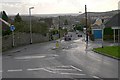
Looking down Brockstone Road
Taken from the junction with Boscoppa Road.
Image: © Tony Atkin
Taken: 12 Nov 2005
0.21 miles
8
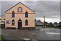
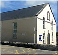
Bethel Chapel
The plaque on the front shows the year 1836 which makes it a relatively early Methodist Church. It is still in use for worship.
Image: © Tony Atkin
Taken: 12 Nov 2005
0.23 miles
9
Housing on the edge of St Austell
This photo was taken from just in front of a roundabout on the ring road.
Image: © Tony Atkin
Taken: 12 Nov 2005
0.23 miles
10
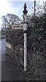
Old Direction Sign - Signpost by Bethel Road, Bethel, St Austell
Pyramid spear finial - 3 arms, 1 missing; Cornwall CC iron spear by the UC road, in parish of St Austell (Restormel District), Bethel, at crossroads with Bethel Road and Bucklers Lane, in pavement by low wall.
Cornwall & Scilly HER.
HER Number: MCO56826 https://www.heritagegateway.org.uk/Gateway/Results_Single.aspx?uid=MCO56826&resourceID=1020
To be surveyed
Milestone Society National ID: CW_SX0352
Image: © Milestone Society
Taken: Unknown
0.24 miles