IMAGES TAKEN NEAR TO
Fore Street, PAR, PL24 2NH
Introduction
This page details the photographs taken nearby to Fore Street, PL24 2NH by members of the Geograph project.
The Geograph project started in 2005 with the aim of publishing, organising and preserving representative images for every square kilometre of Great Britain, Ireland and the Isle of Man.

There are currently over 7.5m images from over14,400 individuals and you can help contribute to the project by visiting https://www.geograph.org.uk
Image Map
Images are licensed for reuse under creativecommons.org/licenses/by-sa/2.0
Notes
- Clicking on the map will re-center to the selected point.
- The higher the marker number, the further away the image location is from the centre of the postcode.
Image Listing (40 Images Found)
Images are licensed for reuse under creativecommons.org/licenses/by-sa/2.0
Image
Details
Distance
1
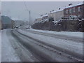
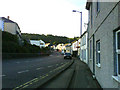
Fore Street St Blazey in the snow looking towards St Austell
This picture was taken in November 2005 when there was a short, sharp blizzard which for a few hours caused chaos.
Image: © Hilary Boase
Taken: Unknown
0.03 miles
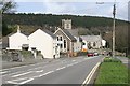
2
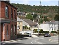
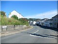
Northern end of the village of St Blazey
On the slope behind the village is the conifer plantation of Prideaux Wood.
Image: © Tony Atkin
Taken: 28 Mar 2006
0.04 miles
3
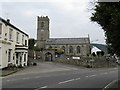
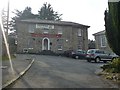
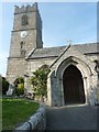
Church of St. Blaise, St. Blazey, Cornwall
This church, built in 1842, stands in a prominent position on the north side of the A390 opposite the junction with Station Road. The 'Cornish Arms' is seen to the left.
Image: © Dr Neil Clifton
Taken: 1 Apr 2009
0.08 miles
5
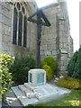
St Blazey War Memorial
This memorial found to the south side of Image is one of the few that I have seen to list a female name amongst the fallen in the 1914-1918 war.
Image: © Steve Barnes
Taken: 3 Sep 2010
0.09 miles
8
Packhorse Inn, St Blazey
This public house is to the north eastern end of the village on the A390, Bridge St.
Image: © Steve Barnes
Taken: 4 Sep 2010
0.10 miles
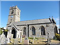
9
Church of St Blase, St Blazey
This church, built in 1842, stands in a prominent position on the north side of the A390 opposite the junction with Station Road.
Image: © Steve Barnes
Taken: 3 Sep 2010
0.10 miles
10
St Blazey
Showing the church behind the old schoolhouse which is now used as a nursery school.
Image: © Tony Atkin
Taken: 28 Mar 2006
0.10 miles