IMAGES TAKEN NEAR TO
St. Blazey Road, PAR, PL24 2JA
Introduction
This page details the photographs taken nearby to St. Blazey Road, PL24 2JA by members of the Geograph project.
The Geograph project started in 2005 with the aim of publishing, organising and preserving representative images for every square kilometre of Great Britain, Ireland and the Isle of Man.

There are currently over 7.5m images from over14,400 individuals and you can help contribute to the project by visiting https://www.geograph.org.uk
Image Map
Images are licensed for reuse under creativecommons.org/licenses/by-sa/2.0
Notes
- Clicking on the map will re-center to the selected point.
- The higher the marker number, the further away the image location is from the centre of the postcode.
Image Listing (15 Images Found)
Images are licensed for reuse under creativecommons.org/licenses/by-sa/2.0
Image
Details
Distance
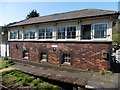
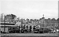
2
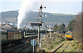
St Austell: at St Blazey
A steam-hauled excursion for Newquay arrives behind ‘Black Five’ 45407. Looking north-north-west. Semaphore signalling survives here
Image: © Martin Bodman
Taken: 26 Mar 2007
0.04 miles
3
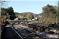
Par Curve
Looking into St.Blazey yard from the bridge over the River Par.
Image: © Martin Addison
Taken: 27 Oct 2012
0.08 miles
4
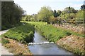
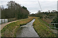
Rail and Water at St Blazey Middle Crossing
Looking towards Par from St Blazey Middle crossing the single track Par to Newquay railway is on the right. This stream was many years ago once white with clay pollution but now is clear. A path follows the stream towards Par.
Image: © roger geach
Taken: 17 May 2010
0.12 miles
5
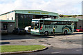
Middleway Garage
Home of Roselyn coaches on St.Blazey Road. Roselyn handle most local schools traffic and also run coach tours throughout the UK and to European destinations. Here one of their Plaxton Premiere bodied Volvo's.
Image: © Martin Addison
Taken: 1 Nov 2012
0.12 miles
6
Unnamed stream at Par
A single track railway runs alongside to the right.
Image: © Kate Jewell
Taken: 9 Feb 2010
0.14 miles
7
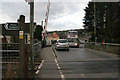
Level crossing between Par and St Blazey
The railway branch line to Newquay crosses St Andrew's Road.
Image: © Kate Jewell
Taken: 9 Feb 2010
0.14 miles
8
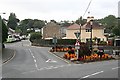
Flowers at the Junction
A September flower display brightens up this road junction on the road junction at the edge of St Blazey.
Image: © Tony Atkin
Taken: 22 Sep 2007
0.16 miles
9
St Blazey Locomotive Depot
View westward, to the semi-roundhouse behind the locomotives in the yard. The Depot is beside the Cornwall Minerals line (closed in 1968) that came down to Par Harbour and Fowey from St Blazey station on the Par - Newquay branch. This fairly small Depot (in the Newton Abbot Division, coded 83E by BR) provided locomotives for the local branches, notably the china-clay traffic. In 1954, the allocation of 37 engines was all steam, comprising:- 2 4-6-0s, 4 2-6-0s, 2 2-8-0Ts, 16 2-6-2Ts, 12 0-6-0Ts and 1 0-4-2T. However, by 1960 when this photograph was taken, main-line Diesels had already begun to take over: Type 2 Diesel-Hydraulic No. D6308 was in the yard, together with 2-6-2T No. 4167, 0-6-0T No. 7446 and 2-8-0T No. 5264. The Depot closed in 4/62, but has survived as a Diesel Depot: since 25/4/87 the Diesels have been serviced at a small straight-shed (out of view to the right), while the semi-roundhouse has been kept intact under a Preservation Order.
Image: © Ben Brooksbank
Taken: 23 Apr 1960
0.17 miles
10
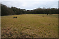
Open meadow at Par Pond
This open grass land is a pleasant relief after walking through the dense wet woodland at Par Pond. The trees that surround this meadow, mainly alder and willow, are able to absorb oxygen from waterlogged areas and have their roots in water.
Image: © Kate Jewell
Taken: 9 Feb 2010
0.18 miles