IMAGES TAKEN NEAR TO
School Lane, FOWEY, PL23 1QA
Introduction
This page details the photographs taken nearby to School Lane, PL23 1QA by members of the Geograph project.
The Geograph project started in 2005 with the aim of publishing, organising and preserving representative images for every square kilometre of Great Britain, Ireland and the Isle of Man.

There are currently over 7.5m images from over14,400 individuals and you can help contribute to the project by visiting https://www.geograph.org.uk
Image Map
Images are licensed for reuse under creativecommons.org/licenses/by-sa/2.0
Notes
- Clicking on the map will re-center to the selected point.
- The higher the marker number, the further away the image location is from the centre of the postcode.
Image Listing (144 Images Found)
Images are licensed for reuse under creativecommons.org/licenses/by-sa/2.0
Image
Details
Distance
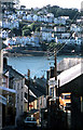
3
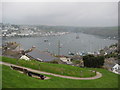
View over the River Fowey
View over the River Fowey and Fowey Harbour from above Polruan.
Image: © Philip Halling
Taken: 15 Apr 2011
0.03 miles
4
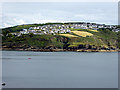
Polruan
Viewed from the South West Coast Path near Coombe Haven.
Image: © John Lucas
Taken: 8 Aug 2017
0.03 miles
6
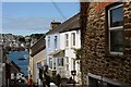
Looking down Fore Street, Polruan
The main road up the hill, from the seafront and ferry pier. Fowey can be seen across the river.
Image: © Oliver Mills
Taken: 15 Jul 2015
0.04 miles
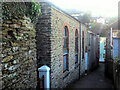
7
Polruan Fore Street 1979
View towards Fowey.
Image: © Crispin Purdye
Taken: Unknown
0.05 miles
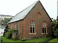
8
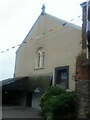
Chapel retreat
A former Free Church now holiday accommodation.
Image: © Paul Barnett
Taken: 1 Jan 2015
0.05 miles
10
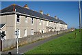
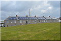
A High Terrace
This terrace of houses in Polruan faces onto the green overlooking the sea. Behind these houses lies most of Polruan built on the steep northerly slope leading down to the sheltered harbour.
Image: © Tony Atkin
Taken: 25 Jul 2010
0.05 miles