IMAGES TAKEN NEAR TO
Cresthill Road, PLYMOUTH, PL2 2RG
Introduction
This page details the photographs taken nearby to Cresthill Road, PL2 2RG by members of the Geograph project.
The Geograph project started in 2005 with the aim of publishing, organising and preserving representative images for every square kilometre of Great Britain, Ireland and the Isle of Man.

There are currently over 7.5m images from over14,400 individuals and you can help contribute to the project by visiting https://www.geograph.org.uk
Image Map (Loading...)


Getting Data...Please wait
Leaflet Map data © OpenStreetMap
Images are licensed for reuse under creativecommons.org/licenses/by-sa/2.0
Notes
- Clicking on the map will re-center to the selected point.
- The higher the marker number, the further away the image location is from the centre of the postcode.
Image Listing (21 Images Found)
Images are licensed for reuse under creativecommons.org/licenses/by-sa/2.0
Image
Details
Distance
1
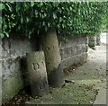
Old Boundary Markers on Beacon Park Road, Plymouth
Two boundary markers in Plymouth under a hedge and against a front garden wall on the north side of the junction of Beacon Park Road and Fircroft Road.
On the left is Municipal Boundary Marker DV_DMBB01pb. Inscribed with an upwards pointing arrow and D.M.B. / 5 / 10.S for Devonport Municipal Borough.
On the right is Parish Boundary Marker DV_WPBS01pb. Inscribed WESTON / P for Weston Peverell parish.
Image: © T Jenkinson
Taken: 21 Jul 2012
0.07 miles
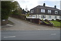
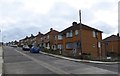
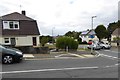
3
Bungalows, on Beacon Park Road, Plymouth
Image: © Roger Cornfoot
Taken: 2 Jan 2010
0.08 miles
4
Albion Drive, Plymouth
The road name is a reminder that this area of Beacon Park was for many years the home of Plymouth Albion Rugby Club. The club now plays at the Brickfields in Devonport, and the Beacon Park grounds are given to housing.
Image: © David Smith
Taken: 26 Sep 2014
0.08 miles
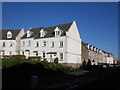
5
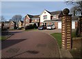
Albion Drive, Plymouth
A rather exclusive little estate of detached houses at the end of a drive off Beacon Park Road, with a footpath (to the right of the gatepost) connecting through to Llantillio Drive past the Beacon Down Sports Ground.
Image: © Derek Harper
Taken: 27 Feb 2010
0.11 miles
6
Beacon Down Avenue
The junction with Conway Gardens. Beacon Down is a reminder that this hill was the site of a warning beacon for the Spanish Armada in 1588
Image: © David Smith
Taken: 26 Sep 2014
0.12 miles
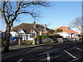
7
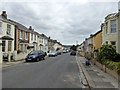
Cedarcroft Road, Plymouth
A residential road with assorted houses
Image: © David Smith
Taken: 26 Sep 2014
0.15 miles
8
The end of Beacon Down Avenue
This road is one of several incorporating the word "beacon", a reminder that one of the warning beacons for the Armada in 1588 was on this hill
Image: © David Smith
Taken: 26 Sep 2014
0.17 miles
9

Old Boundary Marker on Beacon Park Road, Plymouth
Municipal Boundary Marker on the north side of Beacon Park Road, Plymouth, against the front garden wall of No. 151. Inscribed D.M.B. (Devonport Municipal Borough) / 4. Devonport borough was established in 1837 following the Municipal Corporations Act 1835.
Milestone Society National ID: DV_DMBB02pb
Image: © T Jenkinson
Taken: 21 Jul 2012
0.18 miles