IMAGES TAKEN NEAR TO
Lerryn, LOSTWITHIEL, PL22 0PX
Introduction
This page details the photographs taken nearby to PL22 0PX by members of the Geograph project.
The Geograph project started in 2005 with the aim of publishing, organising and preserving representative images for every square kilometre of Great Britain, Ireland and the Isle of Man.

There are currently over 7.5m images from over14,400 individuals and you can help contribute to the project by visiting https://www.geograph.org.uk
Image Map
Images are licensed for reuse under creativecommons.org/licenses/by-sa/2.0
Notes
- Clicking on the map will re-center to the selected point.
- The higher the marker number, the further away the image location is from the centre of the postcode.
Image Listing (63 Images Found)
Images are licensed for reuse under creativecommons.org/licenses/by-sa/2.0
Image
Details
Distance
1
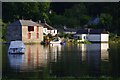
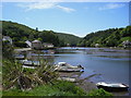
Evening at Lerryn
Looking towards the Quay at Lerryn. At spring tides pleasure boats bring passengers up here to enjoy the peace, tranquility and the good local pub
Image: © Amanda King
Taken: 15 Jun 2010
0.01 miles
3
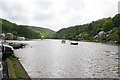
Lerryn at high tide
Looking down stream from the car park. The large building on the left is Image, restored since the date of that photograph from a derelict warehouse to become a community building.
The centre of Lerryn is difficult to photograph for any particular grid square as it sits right in the corner of four squares!
Image: © Kate Jewell
Taken: 13 May 2007
0.02 miles
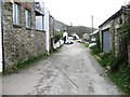
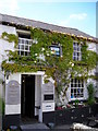
4
Building ('Red Store') next to the River, Lerryn, St Veep Community
Derelict warehouse and boathouse by the riverside; the outside staircase caught my eye. There is an entrance to the boathouse from the river at basement level. The building is listed, Grade II, stated to be early 19C.
Image: © Humphrey Bolton
Taken: 8 Mar 2001
0.03 miles
7
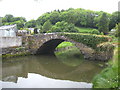
Lowertown Bridge, Lerryn
This bridge over a small creek was constructed in the early 1900s to bring coal from where it was landed at Lerryn Quay, where Lerryn Quay House now stands Image
Image: © Rod Allday
Taken: 17 May 2011
0.03 miles
9
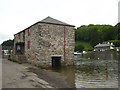
The Red Store beside the river at Lerryn
The Grade II Listed Red Store was built in about 1870 as a storehouse for goods such as fertiliser and corn that were shipped up and down the River Lerryn until the early 20th Century. During the Second World War it was used to store salvage to help the war effort and in the 1950s the top floor was used as a youth club. The building fell into disuse and was purchased by the Parish Council in 2002 for renovation and refurbishment to provide a community facility comprising two craft workshops on the top floor and on the lower floor a flexible multi-use area.
Image: © Rod Allday
Taken: 17 May 2011
0.03 miles
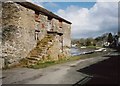
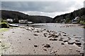
10
The River Lerryn at low tide, Lerryn, St Winnow
The building close to the river is at Little Quay. The bridge is in the distance.
Image: © Humphrey Bolton
Taken: 8 Mar 2001
0.04 miles