IMAGES TAKEN NEAR TO
LOSTWITHIEL, PL22 0HU
Introduction
This page details the photographs taken nearby to PL22 0HU by members of the Geograph project.
The Geograph project started in 2005 with the aim of publishing, organising and preserving representative images for every square kilometre of Great Britain, Ireland and the Isle of Man.

There are currently over 7.5m images from over14,400 individuals and you can help contribute to the project by visiting https://www.geograph.org.uk
Image Map
Images are licensed for reuse under creativecommons.org/licenses/by-sa/2.0
Notes
- Clicking on the map will re-center to the selected point.
- The higher the marker number, the further away the image location is from the centre of the postcode.
Image Listing (13 Images Found)
Images are licensed for reuse under creativecommons.org/licenses/by-sa/2.0
Image
Details
Distance
1
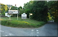
Lostwithiel: road junction at Hillhead
Turn left for Lostwithiel town, turn right for Bodmin. The lane beyond is one route through to Lanlivery
Image: © Martin Bodman
Taken: 27 Apr 2011
0.02 miles
2
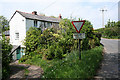
Lostwithiel: at Hillhead
The house stands within a triangle of roads.
Image: © Martin Bodman
Taken: 27 Apr 2011
0.03 miles
3
Junction, Hillhead
A side road, Bodmin Hill, leaves the B3268 on the left. Both roads drop down to Lostwithiel.
Image: © Derek Harper
Taken: 16 Aug 2016
0.04 miles
4
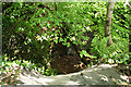
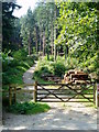
Lostwithiel: Restormel Royal Mine
Looking down into a deep cutting by the probable entrance to the deep adit of the iron mine, which had its most productive period in the nineteenth century. It was visited by Queen Victoria in the 1840s, hence the 'Royal' appellation
Image: © Martin Bodman
Taken: 27 Apr 2011
0.06 miles
5
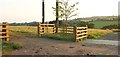
Field entrance near Bodardle
On the other side of Bodmin Hill from Image
Image: © Derek Harper
Taken: 16 Aug 2016
0.11 miles
6
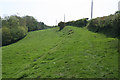
Lostwithiel: by the site of Restormel iron mine
The Restormel Royal Mine site occupied a linear sett, running north-south, which included the woodland to the left. Workings were partly in an openwork and partly underground. 200,000 tons of iron ore was raised between the 1850s and closure in 1886. The ore was taken by tramway, which included an incline plane to lower wagons to the Fowey valley. Horses then hauled the freight to quays on the Fowey at Lostwithiel town
Image: © Martin Bodman
Taken: 27 Apr 2011
0.13 miles
7
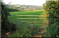
Field near Bodardle
From Bodmin Hill, looking towards the Fowey valley.
Image: © Derek Harper
Taken: 16 Aug 2016
0.13 miles
8
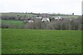
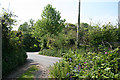
Penquite
A small group of houses at the head of a steep valley running down to Lostwithiel.
Image: © Tony Atkin
Taken: 14 Apr 2006
0.15 miles
9
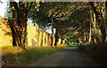
Bodmin Hill
The lane down into Lostwithiel runs past the wall of Delancey, glowing in late sunlight.
Image: © Derek Harper
Taken: 16 Aug 2016
0.16 miles